
Held at: | Private Collection |
Reference: | gc |
Source: | Research at Herefordshire Record Office |
Title: | Land tax in Newton & Ewyas Lacy |
Place name: | Newton |
Date: | 1700’s 1800’s |
Description:
Land Tax Records
Land Tax returns are records that can tell us about Land holdings at the end of the 17th century and through to the 1830’s. Who owned them and who occupied them. They exist in the Herefordshire Record Office for the parishes of Ewyas Lacy for the years from 1772 to 1838, the earlier ones from 1697 to 1771 being missing.
Land Tax was first raised in 1697 to pay for William III’s campaign against the French. Originally the tax was on all profits from Public Offices, on Incomes, Profits from Land, Mines and Mortgages. However by 1733 the Tax on Incomes had proved very difficult to collect and the tax had come to fall exclusively on land and tithes.
The Land Taxes were based on a Survey of 1692 and whilst the Tax Rate was adjusted from time to time the basic valuation remained substantially unchanged. The records therefore reflect the Farms and holdings as they existed at the end of the 17th Century.
They were mainly concerned with two classes of people
· Those who Paid the Tax, in the main this was the Occupier
· Those who had the Voting rights associated with the Property, that is the Owners.
In Newton 14 farms paid Land Tax with valuations in the range of 4s-0d to £3-1s-0d per year. These sums would reflect the value and size of the farm in 1692 at the time of the original survey of 1692. Since all farms progressively grew in size over the years the tax does not represent comparative values at other times. At the time of the Tithe Map in 1844 these 14 farms ranged in size from 154 acres to 44 acres with a wide variation in the effective Tax per acre.
From an examination of the Farm locations and surrounding field patterns, perhaps about 10 of the 14 farms were ancient and had been established from the early times of Norman development. If these 10 farms were originally established as ‘Virgate‘ holdings, each of about 25 acres by modern measure, we have a picture of the sparse intensity of the early land occupation with only about 250 acres of Newton’s 1740 acres being enclosed fields and the rest being open waste common. That is less than 14%.
For those interested in tracing Family history the Land tax records can tell much about family relationships and descent.
Table of Farm size in 1844 and the Land tax rating for the 14 main Farms
Farm/Holding | Size in |
| Tax | Due |
Upper Green | 154 | 3 | 11 | 0 |
New House | 125 | 2 | 16 | 0 |
Gworlodith | 161 | 4 | 2 | 5 |
Quarelly | 96 | 2 | 0 | 0 |
Far House/Pool | 93 | 2 | 8 | 0 |
Green | 90 | 1 | 12 | 0 |
Lower Newton | 88 | 2 | 4 | 0 |
Wain Herbert/Llandee | 85 | - | 4 | 0 |
Castle | 80 | 1 | 16 | 0 |
Old House | 79 | 1 | 13 | 6 |
Newton | 77 | 2 | 8 | 0 |
Yatt | 75 | 1 | 4 | 0 |
Woodlands | 68 | - | 10 | 6 |
Upper House | 44 | 1 | 4 | 0 |
notes:
The Green Farm in 1840 included a large ammount of recently enclosed common land the land tax not having apparently been adjusted.
The Wain Herbert Farm supported an old Charity and its land tax abated due to lower ‘Profits.’
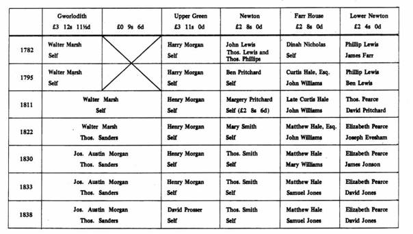
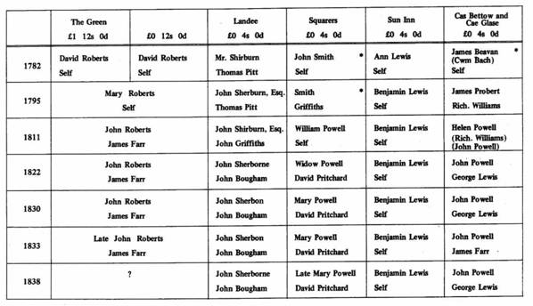
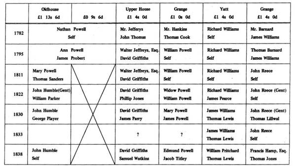
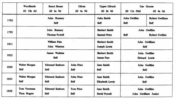
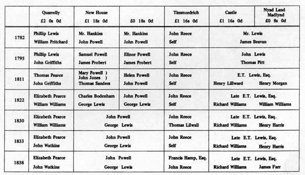
Owners and Occupiers of Land Holdings in Newton Parish 1782 -1838
|
|
|
|
|
Observations:
The four lower tables are images and not searchable.
Ref: gc_nwt_2001