
Title:
Llanthony Priory in the Vale of Ewyas: The Landscape Impact of a Medieval Priory in the Welsh Marches: APPENDICES Date:
2007
| Bibliography |
Books and articles
Adair, J and Cheze-Brown, P 1978 The Pilgrims Way : Shrines and saints in Britain and Ireland Thames and Hudson, London
Aston, M 2000 Monasteries in the Landscape Tempus, Stroud
Aston, M 2004 Interpreting the Landscape: Landscape archaeology and local history Routledge, London
Aston, M and Rowley, T 1974 Landscape Archaeology David and Charles, Newton Abbot
Austin , D 2005 Book review of James Bond’s Monastic Landscapes in Landscapes volume 6 number 2
Barber, C 2003 Exploring Kilvert Country Blorenge, Abergavenny
Bartholomew, J 1900 Touring Atlas and Gazeteer of the British Isles Bartholomew, Edinburgh
Bennett, H 1987 Life on the English Manor: A study of peasant conditions 1150 – 1400 Alan Sutton, Gloucester
Beresford, M and St Joseph, J 1958 Medieval England: An aerial survey Cambridge University Press, London
Bevan-Jones, R 2002 The Ancient Yew: A history of Taxus baccata Windgather Press, Macclesfield
Bond, J 2000 Landscapes of monasticism in Hooke, D (Ed.) Landscape: The richest historical record The Society for Landscape Studies, UK
Bond, J 2004 Monastic Landscapes Tempus, Stroud
Bowden, M 1999 Unravelling the Landscape: An inquisitive approach to archaeology Tempus, Stroud
Bowen, E 1960 Wales : A study in geography and history Cardiff University Press
Briggs, S 2005 Garden Archaeology in Wales in Currie, C (Ed.) Garden Archaeology: A handbook CBA practical handbook 16 Council for British Archaeology, York
Brooks, 1953 Irish Cartularies of Llanthony Prima and Secunda Irish Stationary Office, Dublin
Brown, I 2004 Discovering a Welsh Landscape: Archaeology in the Clwydian Range Windgather Press, Macclesfield
Coates, S and Tucker, D 1978 Water-mills of the Monnow and Trothy and their tributaries Monmouth District Museum Service, Monmouth
Coplestone-Crow, B 1989 Herefordshire Place-Names BAR Series 214
Coppack, G 2006 Abbeys and Priories Tempus, Stroud
Cowley, F 1977 Studies in Welsh History: The Monastic Order in South Wales 1066-1349 University of Wales Press, Cardiff
Craster, O 1963 Guide to Llanthony Priory Her Majesty’s Stationary Office, London
Crawford, O 1953 Archaeology in the Field Pheonix House, London
Darvill, T 1986 The Archaeology of the Uplands: A rapid assessment of archaeological knowledge and practice Council for British Archaeology, London
Davies, D 1971 Welsh Place -names of Breconshire and their meanings pamphlet
Davies, D undated Welsh Place -names and their Meanings pamphlet
Davies, M 1967 Brecon Beacons National Park Guide Her Majesty’s Stationary Office, London
Davies, W 1982 Wales in the Early Middle Ages Leicester University Press, Leicester
Dickinson, J 1950 The Origins of the Austin Canons and their introduction into England Church Historical Society, London
Donkin, R 1978 The Cisterians: Studies in the geography of medieval England and Wales Pontifical Institute of Medieval Studies, Toronto
Dyer, C 2000 Everyday Life in Medieval England Hambledon and London, London
Emery, F 1989 The Landscape in Huw Owens, D (Ed.) Settlement and Society in Wales University of Wales Press, Cardiff
Emery, M 2002 Poulton: The search for a lost Cistercian Abbey in Current Archaeology 180 pp521-525
Evans, C 1953 Monmouthshire: Its history and topography William Lewis, Cardiff
Evans D et al 1980 Excavations at Llanthony Priory, Gwent, 1978 in Monmouthshire Antiquity 4, p5-43
Evans D et al 1984 Further excavation and fieldwork at Llanthony Priory, Gwent in Monmouthshire Antiquity 5 (1-2), p1-61
Evans E 1997 Gwent Historic Churches Survey – Churches in the Archdeaconry of Monmouth, Deanery of Avergavenny Welsh Historic Churches Project Unpublished Cadw report
Evans, E 2003 Early medieval ecclesiastical sites in south-east Wales: Desk-based assessment GGAT report no. 2003/030
Fairclough, G 2007 Made in England: landscape, culture and identity in Conservation Bulletin, issue 54
Fancourt, L undated Llanthony Priory: History and guide Leaflet
Field, J 1989 English Field Names: A dictionary Alan Sutton, Gloucester
Foord, E undated Cathedrals, Abbeys and Famous Churches: Hereford and Tintern including Newport Cathedral and Llanthony Priory Dent, London
Gelling, M 2000 Place-names in the Landscape: The geographical roots of Britain’s placenames Phoenix, London
Gilchrist, R 1999 Middle Ages: churches, castles and monasteries in Hunter, J and Ralston, I The Archaeology of Britain: An introduction from the Upper Palaeolithic to the Industrial Revolution Routledge, London
Greene, P 1992 Medieval Monasteries Leicester University Press, London
Hall, D 1982 Medieval Fields Shire, Princes Risborough
Harris, E, Harris, J and James, N 2003 Oak: A British history Windgather Press, Macclesfield
Hassall, W 1962 How They Lived: 55BC to 1485 Blackwell, Oxford
Hindle, 2002 Medieval Roads and Tracks Shire, Princes Risborough
Hooke, D 2006 England’s Landscape: The West Midlands Collins, London
Huw Owens, D 1989 The Middle Ages in Huw Owens, D (Ed.) Settlement and Society in Wales University of Wales Press, Cardiff
Jack, I 1972 Medieval Wales Hodder and Stoughton, London
Johnson, M 1996 An Archaeology of Capitalism Blackwell, Oxford
Johnson, M 2007 Ideas of Landscape Blackwell, Oxford
Jones, G 1972 Post Roman Wales in Finberg H (Ed.) The Agrarian History of England and Wales I.ii AD 43-1042 Cambridge University Press, London
Jones, R and Page, M 2006 Medieval Villages in an English Landscape: Beginnings and ends Windgather Press, Macclesfield
Kightly, C 1988 A Mirror of Medieval Wales: Gerald of Wales and his journey of 1188 Cadw, Cardiff
Knapp, A and Ashmore, W 1999 Archaeological Landscapes: Constructed, Conceptualized, Ideational in Ashmore, W and Knapp, A (Eds.) Archaeologies of Landscape: Contemporary perspectives Blackwell, Oxford
Knight, C 1960-1980 Unpublished notes and papers on Llanthony Priory
Leighton, D and Silvester, R (2003) Upland Archaeology in the Medieval and Post-medieval Periods in Browne, D and Hughes, S (Eds.) The Archaeology of the Welsh Uplands Royal Commission on the Ancient and Historical Monuments of Wales (RCAHMW), Aberystwyth
Lewis, H 1960 Welsh Dictionary Collins, London
Lloyd Jones, M 1984 Society and Settlement in Wales and the Marches: 500BC to AD1000, BAR British Series 121(i) BAR, Oxford
Locock, M 2006 Deserted Rural Settlements in South-East Wales in Roberts, K (Ed.) Lost Farmsteads: Deserted rural settlements in Wales, CBA research report 148 Council for British Archaeology, York
Longley, D 2004 Status and Lordship in the Early Middle Ages in Aldhouse-Green, M and Howell, R (Eds.) The Gwent County History Vol 1: Gwent in Prehistory and Early History University of Wales Press, Cardiff
Mason, E 1975 Portrait of the Brecon Beacons Hale, London
Maylan, N 2000 Landscapes Working for Monmouthshire: history and archaeology aspect GGAT report no. 00/019
Mee, A 1951 The Kings England: Monmouthshire Hodder and Stoughton, London
Miles, D 2005 The Tribes of Britain Pheonix, London
Monmouthshire County Council 2001 Draft Landscape Study for Unitary Development Plan
Morris, J 2000 Wales : Epic views of a small country Penguin, London
Morriss, R 2005 Roads: Archaeology and architecture Tempus, Stroud
Muir, R 2000 The New Reading the Landscape: Fieldwork in landscape history University of Exeter Press, Exeter
Muir, R 2001 Landscape Detective: Discovering a countryside Windgather Press, Macclesfield
Muir, R 2004 Landscape Encyclopaedia: A reference guide to the historic landscape Windgather Press, Macclesfield
Muir, R 2005 Ancient Trees, Living Landscapes Tempus, Stroud
Neville George, T 1970 British Regional Geology: South Wales HMSO, London
Newman, J 2002 The Buildings of Wales: Gwent/ Monmouthshire Yale University Press, New Haven and London
Nicolson, N 1995 The Counties of Britain: A Tudor atlas by John Speed Pavilion, London
Olding, F 2000 The Prehistoric Landscapes of the Eastern Black Mountains BAR British Series 297
Owen, H 1998 The Place-names of Wales University of Wales Press, Cardiff
Phillips, O 1951 Monmouthshire Robert Hale, London
Platt, C 1969 The Monastic Grange in Medieval England Macmillan, London
Rackham, O 1990 Trees and Woodland in the British Landscape Pheonix, London
Rackham, O 1986 The History of the Countryside Pheonix Press, London
Rees, W 1924 South Wales and the March 1284-1415 Oxford University Press, Oxford
Rhodes , J 1989 Llanthony Priory in Glevensis (The Gloucester and District Archaeological Research Group Review) No 23 p16-30
Rhodes, J 2002 A Calendar of the Registers of the Priory of Llanthony by Gloucester 1457-1466, 1501-1525 Bristol and Gloucester Archaeological Society, Gloucester
Richardson , R 2002 Using Field-Names in Landscapes volume 3 number 2 pp70-83
Rippon, S 2004 Historic Landscape Analysis: Deciphering the countryside CBA practical handbook 16 Council for British Archaeology, York
Robinson, D 1980 The Geography of Augustinian Settlement in Medieval England and Wales Part i and Part ii BAR Series No 80 (i) and (ii)
Rowley, T 2001 The Welsh Border: Archaeology, history and landscape Tempus, Stroud
Saul, N 2005 A Companion to Medieval England 1066 – 1485 Tempus, Stroud
‘Shon’ 1924 The Place-names of Monmouthshire Unpublished
Silvester, R 2004 The Commons and the Waste: use and misuse in mid-Wales in Whyte, I and Winchester, A (Eds.) Society, Landscape and Environment in Upland Britain The Society for Landscape Studies
Simmons, I 2001 An Environmental History of Great Britain Edinburgh University Press, Edinburgh
Smith, N 2003 Longtown, Herefordshire: A medieval castle and borough English Heritage Archaeological Report Series AI/26/2003
Stanford, S 1980 The Archaeology of the Welsh Marches Collins, London
Straughton, E 2004 Beyond Enclosure: upland common land in England and Wales since 1800 in Whyte, I and Winchester, A (Eds.) Society, Landscape and Environment in Upland Britain The Society for Landscape Studies
Sylvester, D 1969 The Rural Landscape of the Welsh Borderland: A study of historical geography McMillan, London
Taylor, C 1975 Fields in the English Landscape Dent, London
Thomas, R 2002 Brecon Beacons: The official national park guide David and Charles, Newton Abbott
Thoresby-Jones, P 1938 Welsh Border Country Batsford, London
Trueman, A 1971 Geology and Scenery in England and Wales Penguin, London
Wade Martins, S 2004 Farmers, Landlords and Landscapes: Rural Britain, 1720-1870 Windgather Press, Macclesfield
Watkins, A 1970 The Old Straight Track Abacus, London
Watt, H 2000 Welsh Manors and their Records The National Library of Wales, Aberystwyth
Williams, D 1976 White Monks in Gwent and the Border Griffin Press, Pontypool
Williams, D 1984 The Welsh Cisterians Volume II Cyhoeddiadau Sistersiaidd, Tenby
Williams, M 1975 The South Wales Landscape Hodder and Stoughton, London
Williamson, T 2003 Shaping Medieval Landscapes: Settlement, Society, Environment Windgather Press, Macclesfield
Winchester , A 2000 Hill farming landscapes in medieval northern England in Hooke, D (Ed.) Landscape: The richest historical record The Society for Landscape Studies,
Primary and Antiquarian Sources
Ayscough, S and Caley, J 1802 Taxatio Ecclesiastica Anglie et Wallie auctoritate P Nicholai IV 1291 Rec. Com., London
Beaumont, J 1803 A Tour throughout South Wales and Monmouthshire Cadell and Davies, London
Bellows, J 1860 Two Days Excursion at Llanthony Abbey and the Black Mountains Steam Press, Gloucester
Bradley, A 1905 In the March and Borderland of Wales Constable, London
Bradney, J 1907 History of Monmouthshire Vol. 1 Part 2a: Hundred of Abergavenny (Part 1) Academy, London
|
|

Caley, J and Hunter J (Eds.) 1814 Valor Ecclesiasticus temp. Henry VIII auctoritate Regia Institutus 1535 Vol. II Rec. Com., London
|
|
Coxe, W 1801 An Historical Tour of Monmouthshire Cadell and Davies, London
Gardner, I 1916 Llanthony Prima in Archaeology Cambrensis vol. 16 p37-66
Gerald of Wales (Giraldus) 1978 The Journey through Wales/ The Description of Wales Trans. Thorpe L Penguin, London
Hassall, C 1812 General view of the agriculture of the county of Monmouth London
Public Records Office 1895 Calendar of Patent Rolls, Edward I 1292-1301 HMSO, London
Public Records Office 1901 Calendar of Patent Rolls, Edward I 1272-1291 HMSO, London
Public Records Office 1903 Calendar of the Charter Rolls vol I, Henry III AD1226-1257 HMSO, London
Public Records Office 1906 Calendar of the Charter Rolls vol II, Henry III and Edward I AD1257-1300 HMSO, London
Public Records Office 1908 Calendar of the Charter Rolls vol III, Edward I and Edward II AD1300-1326 HMSO, London
Public Records Office 1964 List of the Lands of Dissolved Religious Houses (from the List of Ministers Accounts Part II, Henry VII and VIII) Lists and Indexes Supplementary Series No. III Vol. 3 HMSO, London
|
|
Roberts, G 1847 Some Account of Llanthony Priory, Monmouthshire Piickering, London
Wade, G 1909 Monmouthshire Methuen, London
Williams, A and Martin, G (Eds.) 1992 Domesday Book: A complete translation Penguin, London
On line articles, documents and web sites
Archaeological Data Services (ADS) www.ads.ahds.ac.uk/
Archives Network Wales www.archivesnetworkwales.info/
Brecon Beacons National Park Authority www.breconbeacons.org
British History On-line www.british-history.ac.uk
CARN: Core Archaeological Record Index www.rcahmw.org.uk/data/carn.shtml
Cambridge Unit for Landscape Modelling www.uflm.cam.ac.uk/
Clwyd Powys Archaeological Trust www.cpat.org.uk/
Clwyd Powys Archaeological Trust: Historic Landscape Characterisation – The Middle Wye Valley www.cpat.org.uk
Coflein: National Monuments Record for Wales www.coflein.gov.uk/
Countryside Council for Wales http://naturalresources.wales/
Google Earth www.google.com/earth/
Edina Digimap https://digimap.edina.ac.uk/
English Heritage National Monuments Record (NMR)
Geograph British Isles www.geograph.org.uk/
Glamorgan and Gwent Sites and Monuments Record (SMR) www.ggat.org.uk/smr.htm
Gwent Records Office www.llgc.org.uk/cac/cac0004.htm
Herefordshire Historic Environment Record (HER) www.smr.herefordshire.gov.uk
Lewis, S 1849 A Topographical Dictionary of Wales On-line at www.british-history.ac.uk
National Archives www.nationalarchives.gov.uk/
National Library of Wales www.llgc.org.uk/
Natural England – Character Area 99: Black Mountains and the Golden Valley www.naturalengland.org.uk/
Royal Commission on the Ancient and Historical Monuments of Wales https://rcahmw.gov.uk/
Tate Britain www.tate.org.uk
Vision of Britain www.visionofbritain.org.uk
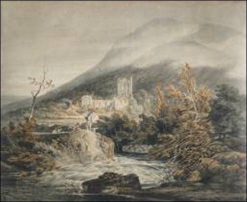
Figure 140: Watercolours of Llanthony Priory, JMW Turner, 1792-1794 (from www.tate.org.uk )
| List of maps and plans used for reference |
Maps
| Bartholomew, undated, Half inch, Sheet 23: Hereford
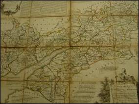
Bowen, E, 1769 An accurate map of the Counties of Gloucester and Monmouth (right)
Dudley Stamp 1930 map of land-use (Digimap) (below) |
|
|
| Ordnance Survey, 1832 one inch, ‘Old Series’: The Black Mountains (Cassini Historical Maps, Map 161)
Ordnance Survey, 1919 one inch, ‘Popular edition’, Sheet 91: Abergavenny and District (below)
Ordnance Survey, 1950 1:625,000 Map of Monastic Britain: South Sheet |

|
| Ordnance Survey, 2005 1:25,000 ‘Explorer’ OL13: Brecon Beacons National Park – Eastern area
Ordnance Survey - modern and historic digital map extracts downloaded from Athena Digimap www.edina.ac.uk/digimap/
Rees, W 1933 Half inch South Wales and the Border in the 14th century
Saxton, C 1637 Map of Monmouthshire
|

Tithe maps and apportionments
Gwatkin, G 1998 Six inch parish map reproduction (from 1839 tithe map) Parish of Llansillo (Herefordshire)
Gwatkin, G 1998 Six inch parish map reproduction (from 1839 tithe map) Parish of Rowlestone (Herefordshire)
Gwatkin, G 1998 Six inch parish map reproduction (from 1842 tithe map) Parish of Walterstone (Herefordshire)
Gwatkin, G 1998 Six inch parish map reproduction (from 1840 tithe map) Township of Llanveynoe (Parish of Clodock, Herefordshire)
Gwatkin, G 1998 Six inch parish map reproduction (from 1840 tithe map) Township of Longtown (parish of Clodock, Herefordshire)
Copy No. 2 Map of the parish of Cwmyoy in the County of Monmouth by W. H. Apperly, surveyor, Hereford. 1852
Map of the hamlet of Bwlch Trewyn situated in the Parish of Cwmyoy and County of Hereford by Robert Gabb, land agent and surveyor, Abergavenny. 1844
Map of the hamlet of Foothog (or Fwddog) situated in the parish of Cwmyoy, County of Hereford by Robt Gabb, landagent &c., Abergavenny. 1843
Map of the parish of Llanigon in the County of Brecon by William Jones, landsurveyor, Belle Vue Place, Brecon. 1845
No. 1 Plan of the parish of Llanvihangel Crucorney in the County of Monmouth. 1848
Plan of the parish of Oldcastle in the County of Monmouth compiled by William Jones, Brecon. 1839
Plans
|
| Moore , E Survey of Upper and Lower Trewin in the Parish of Cwmyoy in the County of Herefordshire 1726 |
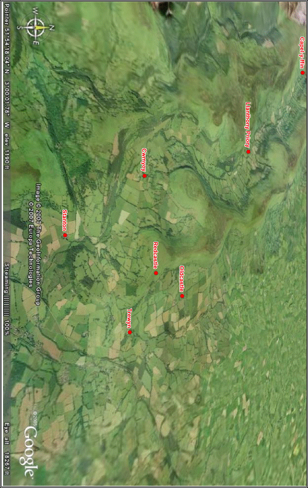
| Appendix 2: Ordnance Survey Old Series one-inch map of the study area (1832) |
Northern section

Southern section

| Appendix 3: Plan of Llanthony Priory precinct and enclosure (After Evans, 1984; Fancourt, undated) |
|
|
|
|


Appendix 5: List of settlement and landscape feature names in the study area

| (From Bartholemew, Ordnance Survey and Tithe Maps for the study area. Meanings from Bradney, 1907; Coxe, 1801; Copplestone-Crow, 1989; Davies, 1967; Davies, undated; Gelling, 2000; Knight, undated; Lewis, 1849; Lewis, 1960; Mee, 1951; Owen, 1998; Wade, 1909) | ||||||
| Name (and alternative recorded names) | OS grid reference | Meaning (Mod E = Modern English, OE = Old English, W = Welsh) | Feature Type | Theme | HER entry (GGAT) | HER entry (CPAT) |
| Afon Honddu |
| Quiet black river or stream (W) | River | Description |
|
|
| Allt-yr-ynys | SO336234 | Wood or steep ascent on the rising ground (W) | Large house | Topography |
|
|
| Bal-bach | SO274266 | Little summit (W) | Hilltop | Topography |
|
|
| Bal-Mawr | SO267271 | Great summit (W) | Hilltop | Topography |
|
|
| Birches (The) (Fedw) | SO316217 | Birches (Mod E) (Birch trees W) | House | Vegetation |
|
|
| Black Lion Inn (Cwmyoy) | SO299234 | Black Lion Inn (Mod E) | Inn | Function |
|
|
| Blacksmiths Anvil | SO250302 | Blacksmiths anvil (Mod E) | Stone | Description |
|
|
| Blaenau | SO257315 | Head of the valley of the yoke (W) | Farmstead | Topography |
| 35829 35830 35831 35833 |
| Blaen-bwch | SO238328 | Head of valley pass (W) | Farmstead | Topography |
| 35800 |
| Blaenyoy (Fach or Old) | SO307245 | Little head of the valley of the yoke (W) | Farmstead | Topography |
|
|
| Blaen-yoy-fawr | SO307245 | Great head of the valley of the yoke (W) | Farmstead | Topography |
|
|
| Boxbush (Upper House) | SO246316 | Box bush (Mod E) | House | Vegetation |
|
|
| Boxtree Cottage | SO313234 | Box tree (Mod E) | House | Vegetation |
|
|
| Bracheu (Brychen) | SO256325 | Spotted, mottled ? (W) | Farmstead | ? |
|
|
| Broadley | SO283285 | Broad clearing (OE) | Farmstead | Topography |
|
|
| Bryn Arw | SO3020 | Upon the hill (W) | Hill | Topography |
|
|
| Bryn Arw | SO313217 | Upon the hill (W) | Settlement (modern) | Topography |
|
|
| Bryn-Arw Farm | SO306206 | Farm upon the hill (W) | Farmstead | Topography |
|
|
| Brynhonndu | SO326224 | Honddu (river) hill (W) | Farmstead | Topography |
|
|
| Bugle (=Bugail) Bridge | SO290273 | Shepherd's bridge (W) | Bridge | Function |
|
|
| Bwlch Bach | SO263286 | Little pass (W) | Ridge | Topography |
|
|
| Bwlch Isaf | SO267277 | Lower pass (W) | Ridge | Topography |
|
|
| Bwlch Trewyn | SO327225 | Pass of the home of Wyn (W) | Farmstead | Topography |
|
|
| Bwlch-yr-Efengyl (y-fingel) | SO237350 | The Gospel (or angel Michael) Pass (W) | Mountain pass | Religious |
|
|
| Cae Brink (= Bryncyn) | ? | Hillock field (W) | Farmstead | Topography |
|
|
| Cae'r-dringol | ? | Field or enclosure on the climb (W) | Farmstead | Land-use/ Topography |
|
|
| Cae-waun | SO273294 | Meadow field or enclosure (W) | Farmstead | Land-use |
|
|
| Capel-y-Ffin | SO255315 | The chapel of the boundary (W) | Hamlet | Religious/ Administrative |
| 3131 20861 35819 65000 |
| Capel-y-Ffin, St Marys Church | SO255315 | The chapel of the boundary (W) | Chapel | Religious/ Administrative |
| 15876 15878 32446 35820 |
| Carnau | SO244323 | Cairn (W) | Farmstead | Man-made feature |
|
|
| Castel fferwynt (The castle) | SO250328 | Chilly ? wind castle (W) | Farmstead | Man-made feature |
| 5806 |
| Castle (The) | SO317236 | Castle (Mod E) | Ruined farmstead/ enclosure | Man-made feature |
|
|
| Chapel Farm | SO255315 | Chapel farm (Mod E) | Farmstead | Man-made feature |
|
|
| Chwarel y fan Quarry | SO258294 | Quarry of the peak (W) | Quarry | Man-made feature |
|
|
| Clydd or Clyth, Lower = Clwyd? | SO323236 | Rocky stream? (gate to mountain)? (W) | Farmstead | Topography/ Location |
|
|
| Clydd or Clyth, Upper =Clwyd? | SO320236 | Rocky stream? (gate to mountain)? (W) | Farmstead | Topography/ Location |
|
|
| Cnapiau | SO239349 | Lump (yoke knob) (W) | Hill side | Topography |
| 35805 |
| Coed Cwn-iou | SO3022 | Cwmyoy wood (W) | Wood | Ownership | 06063g |
|
| Coed Farm (Ty'n-y-coed) | SO298226 | Wood farm (house in the wood) (W) | Farmstead | Location |
|
|
| Coed Graig-ddu | SO2926 | Black rocks wood (W) | Wood | Topography |
| 21847 21873 21875 |
| Coed Pen-y-clawdd | SO3020 | End of the bank (dyke wood) (W) | Wood | Topography |
|
|
| Coed Robin | SO2823 | Robin’s (pers. name?) wood (W/ Mod E) | Wood | Personal name | 06065g | 21845 |
| Coed Ty Canol | SO2824 | Middle house wood (W) | Wood | Man-made feature |
|
|
| Coed Tyle | SO2922 | Hillside wood (W) | Wood | Topography |
|
|
| Coed y Cerrig | SO298217 | Wood of the stones (W) | Wood | Topography |
|
|
| Court Farm (The Court) | SO288278 | (Priory) court farm (Mod E) | Farmstead | Man-made feature | 01603g |
|
| Craig View | SO301227 | Rock view (W/ Mod E) | House (modern) | Topography |
|
|
| Cwm Brychen | SO2532 | Spotted, mottled ? Valley (W) | Valley | Description |
| 22251 35828 |
| Cwm Coed Cerrig | SO3021 | Valley of the wood of the stones (W) | Valley | Topography/ Vegetation |
|
|
| Cwm Coed-y-cerig | SO299214 | Valley of the wood of the stones (W) | Farmstead | Topography/ Vegetation |
|
|
| Cwm Iau | SO3023 | Valley of the yoke (W) | Valley | Topography |
|
|
| Cwm Siarpal (Sharpole, Sharpwell) = Siarl-bal? | SO291288 | Chariot hall? (W) Steep? (OE) Spade? (W) Summit? (W) valley (W) | Valley | ? |
|
|
| Cwm-bwchel (buchiel) =Bugail or Bwlch | SO283274 | Valley of the shepherd or herdsman (of the pass) (W) | Farmstead | Topography/ Personal | 01745g |
|
| Cwm-bwchel (buchiel) =Bugail or Bwlch | SO2827 | Valley of the shepherd or herdsman (of the pass) (W) | Valley | Topography/ Personal |
|
|
| Cwmyoy (= Cwm-iau) | SO298234 | Valley of the yoke (W) | Hamlet | Topography |
|
|
| Cwmyoy Farm (The Farm) | SO299232 | Valley of the yoke (W) | Farmstead | Topography |
|
|
| Cwmyoy, St Martin's Church | SO298234 | Valley of the yoke (W), St Martins church (ME) | Church | Religious | 01632g 01715g 08157g 01714g |
|
| Cwraurwaun | SO311252 | Quarry on the moorland (W) | Quarry | Function/ Topography |
|
|
| Cyttre (Cydor, Cuttrey) = Cut+tre | SO273296 | Cottage homestead (W) | Farmstead | Function |
|
|
| Dan-y-bwlch | SO318224 | Under the pass (W) | Farmstead | Topography | 01608g |
|
| Daren Fawr | SO294239 | Great rocky hillside (W) | Farmstead | Topography |
|
|
| Daren-ganol | SO293243 | Back with (?) rocky hillside (W) | Farmstead | Topography |
|
|
| Daren-isaf | SO297239 | Lower rocky hillside (W) | Farmstead | Topography |
|
|
| Daren-uchaf | SO293244 | Highest rocky hillside (W) | Farmstead | Topography |
|
|
| Darren | SO2924 | Rocky hillside (W) | Crags | Topography |
|
|
| Darren Lwyd | SO239334 | Grey or brown rocky hillside | Hillside | Topography |
| 9414 35535 35537 |
| Deri-duon (=Derw-duo?) | SO279294 | Black oaks (?) (W) | Farmstead | Vegetation |
|
|
| Dial Garreg | SO283240 | Revenge stone (W) | Stone cross | Man-made feature |
|
|
| Dinas Arthur | ? | Arthur's fortress (W) | Farmstead | Personal name/ Man-made feature |
|
|
| Dol Alice (Dolau) | SO277288 | Alice 's (personal name) meadow(s) or dale (W) | Farmstead | Personal name/ Land-use |
|
|
| Dol-Gilbert | SO275286 | Gilbert's (personal name) meadow(s) or dale (W) | Farmstead | Personal name |
|
|
| Erw-serth | ? | Steep acre (W) | Cottage | Topography |
|
|
| Ewyas, Vale of |
| Sheep district (W) | Valley | Land-use |
|
|
| Farms Mill | SO300228 | Farms mill (Mod E) | Mill | Function |
|
|
| Ffynnon y Parc | SO239358 | Spring or well of the park (W) | Ridge | Topography |
|
|
| Footway | SO304268 | Footpath (Mod E) | Farmstead | Man-made feature |
|
|
| Gaer Farm (Ty'r-gaer) | SO298219 | Fort farm (house on the fort) (W) | Farmstead | Man-made feature |
|
|
| Garn Farm (Garn-fawr, The Garn) | SO270304 | Great cairn farm (W) | Farmstead | Man-made feature |
|
|
| Garn Wen | SO281256 | White cairn (W) | Hilltop | Man-made feature |
|
|
| Glandwr (Landwr) | SO328257 | Bank of the water (W) | Farmstead | Topography |
|
|
| Graig Ddu | SO288265 | Black rocks (W) | Crag | Topography |
|
|
| Graig Ddu (Creigiau-duon) | SO292266 | Black rocks (black yoke rocks) (W) | Farmstead | Topography |
|
|
| Graig Ddu Fawr | SO293262 | Great black rocks (W) | Woodland | Topography |
| 21512 21513 |
| Grange, The (Tyawyn, Tygwyn) | SO250314 | The grange (Mod E) (white house) (W) | Farmstead | Description |
|
|
| Groes-lwyd (Croes) | SO323224 | Grey or brown cross (may mean holy?) (W) | Farmstead | Man-made feature |
|
|
| Grove | SO289287 | Grove (Mod E) | Wood | Vegetation |
|
|
| Guewaral (=Gwarallt?) | SO251321 | Nape of hillside or wood (W) | House | Topography |
|
|
| Gunter's Farm | SO282278 | Gunter's (personal name?) farm | Farmstead | Personal name |
|
|
| Gwaun-lluarn = lleian | ? | Nun's meadow (W) | Farmstead | Religious |
|
|
| Half Moon Hotel | SO286279 | Half moon hotel (Mod E) | Inn | Function |
|
|
| Hatterrall Hill (Hatyrel, Hatterras, Fynydd y Gadair) |
| Mountain of ? on the ? (W) | Hill | Topography ? |
|
|
| Hendy | ? | The old house (W) | Farmstead | Description |
|
|
| Henllan, Lower (Isaf) | SO294256 | Lower old enclosure, church or sacred place(W) | Farmstead | Religious |
|
|
| Henllan, Uchai | SO292259 | Upper old enclosure, church or sacred place (W) | Farmstead | Religious |
|
|
| Henllan, Upper (Ganol = Canol) | SO291258 | Middle old enclosure, church or sacred place (W) | Farmstead | Religious |
|
|
| Hoel-y-parc | SO284284 | Road on or of the park or field (W) | Farmstead | Man-made feature |
|
|
| Hwlwm (Yr heol-lwm) | SO294247 | The bare road (W) | Wood | Description |
|
|
| Llanerch | SO246346 | Glade (W) | Farmstead | Vegetation |
|
|
| Llanthony (Llanddewi Nant Honddu) | SO287276 | The church of St David on the Honddu brook (W) | Hamlet | Religious/ Topography |
|
|
| Llanthony (Llanddewi Nant Honddu) Priory | SO288278 | The church of St David on the Honddu brook (W) | Priory | Religious/ Topography | 01731g 01732g 01720g 01721g 01735g 01740g |
|
| Llanthony Slade |
| The church of St David on the Honddu brook (W), marshy valley (OE) | Manorial estate | Religious/ Topography |
|
|
| Llanthony, St Davids Church | SO | The church of St David on the Honddu brook (W) | Church | Religious/ Topography | 01737g 08211g |
|
| Llanthony Wood | SO2922 | The church of St David on the Honddu brook wood (W) | Wood | Ownership |
|
|
| Llanfihangel Court | SO3220 | Church of Michael the archangel, hill or knoll corner (W) court (Mod E) | Large house | Religious/ Topography | 01619g |
|
| Llanvihangel Crucorney (Crugorney = Crug cornal, Michaelston) | SO3220 | Church of Michael the archangel, hill or knoll corner (W) (Michael town (OE)) | Village | Religious/ Topography |
|
|
| Llanvihangel Crucorney, St Michaels Church | SO3220 | Church of Michael the archangel, hill or knoll corner (W) | Church | Religious/ Topography | 08183g 02244g+F26 |
|
| Llech y Lladron | SO251360 | Slate or broad stone of the thief (W) | Ridge | Personal |
|
|
| Llwygy (Llwygu), Great | SO321216 | Fatiguing (ie in a remote spot) (W) | Farmstead | Location |
|
|
| Llwygy (Pen Llwygu), Little | SO317222 | Fatiguing (ie in a remote spot) (W) | Farmstead | Location |
|
|
| Llwyn-Badam (Pen-y-weirlod) | SO273288 | Birch (?) grove (end of the meadow) (W) | Farmstead | Vegetation/ Location |
|
|
| Llwyncelyn | SO309218 | Holly bush or grove (W) | Farmstead | Vegetation | 01613g |
|
| Llwyn-on | SO279289 | Ash grove (W) | Farmstead | Vegetation |
|
|
| Llygad-yw | ? | The eye of the (stream called the) yew (W) | Farmstead | Topography/ Vegetation |
|
|
| Loxidge (Llociau) = Llocesau | SO285286 | Shelter or refuge (W) | Farmstead | Function |
|
|
| Loxidge (Loxy) Tump = Llocesau | SO286289 | Shelter or refuge (W) | Hillside | Function |
|
|
| Loxidge wood = Llocesau | SO286285 | Shelter or refuge (W) | Wood | Function |
|
|
| Maerdy | SO247334 | Grange or house of steward (W) | Farmstead | Function |
| 9411 9415 |
| Maes-y-ffin (Felin) | SO259308 | Meadow, field or ploughland of the border (or mill) (W) | Farmstead | Land-use/ Location |
| 9412 |
| Meas-y-Beran (Berrin) | SO299266 | Meadow, field or ploughland (W) of the pear? (OE?) | Farmstead | Land-use |
|
|
| Melin | SO287276 | Mill (W) | Mill | Function |
|
|
| Monastery (The) | SO252314 | The monastery (Mod E) | Religious house | Function |
|
|
| Nant Bwch | SO238323 | Buck stream (W) | Stream | Fauna |
| 5132 8922 9533 9558 80993 |
| Nant Ganol | SO228334 | Middle stream (W) | Stream | Location |
| 5397 80991 80992 |
| Nant Hywel | SO251337 | Bold? well stream (W) | Stream | Man-made feature |
| 3132 9517 |
| Nant Isaf | SO232328 | Lower stream (W) | Stream | Location |
|
|
| Nant Uchaf | SO223335 | Highest stream (W) | Stream | Location |
|
|
| Nant Vision = Ffyshant | SO267313 | Border stream ? stream (W) | Stream | Topography/ Administrative |
|
|
| Nant y Ffin | SO262313 | Stream of the border (W) | Stream | Administrative |
|
|
| Nant-y-carnau | SO274286 | Stream of the cairn (W) | Stream | Topography |
|
|
| Nant-y-carnau (Nant-y-carn) | SO273285 | Stream of the cairn (W) | Farmstead | Topography |
|
|
| Nantygwyddel (Nant-y-gwisel) | SO277282 | The Irishman's stream (W) | Farmstead | Topography/ Personal |
|
|
| Nantymair (Lower house) | SO326243 | Stream of St Mary (W) | Farmstead | Religious |
|
|
| Nant-yr-Annell | SO249343 | Stream of the ? (W) | Stream | ? |
|
|
| Nef | ? | Heaven (W) | Farmstead | Religious |
|
|
| Neuadd | SO295233 | Hall or mansion (W) | Farmstead | Function |
|
|
| Neuaddllwyd (Noyaddllwyd) | SO283252 | Grey hall (W) | Farmstead | Function |
|
|
| Old Post Office | SO328253 | Old post office (Mod E) | House | Function |
|
|
| Oldcastle (Hen-Gastell) | SO325245 | Old castle (W) | Fortified settlement | Man-made feature |
|
|
| Oldcastle Court (The Court) | SO325245 | Old castle court (W/ Mod E) | Farmstead | Man-made feature | 01603g |
|
| Oldcastle, St John the Baptist Church | SO325245 | Old castle (W/ Mod E), St John the Baptist church | Church | Religious | 01604g 01605g 08234g |
|
| Pandy | SO3322 | Fulling mill (W) | Village | Function |
|
|
| Parc Bach | SO245346 | Little park or field (W) | Area of fields | Land-use |
| 35807 35813 35814 |
| Parc bach | SO244346 | Little park or field (W) | Farmstead | Land-use |
| 9407 |
| Penbeili Glas (Pen-y-beili glas) | SO274293 | The top of the bailifs green (green court) (W) | Farmstead | Land-use/ Location/ Ownership |
|
|
| Pen-castell | SO275280 | Castle end (W) | Farmstead | Man-made feature |
|
|
| Penheol-y-castell | ? | End of the castle wood (W) | Farmstead | Topography |
|
|
| Penllinau (Pen-lan) | SO280297 | Top or end of pool ? (top of bank) (W) | Farmstead | Topography |
|
|
| Pen-rhiw | SO303222 | Side of the hill (W) | House | Topography |
|
|
| Pentre, The (Pentre-bach) | SO297234 | End of village (lowland settlement, little village) (W) | Hamlet | Man-made feature |
|
|
| Pentwyn Camp |
| End of top of the hill (W), camp (fort) (Mod E) | Hillfort | Topography | 01607g |
|
| Pentwyn, Lower | SO319228 | End of top of the hill (W) | Farmstead | Topography |
|
|
| Pentwyn, Upper | SO317233 | End of top of the hill (W) | Farmstead | Topography |
|
|
| Pen-y-beacon | SO244366 | Top of the beacon (W) | Hill | Topography |
|
|
| Pen-y-Bont | SO325208 | End of the bridge (W) | Hamlet | Location/ Man-made feature |
|
|
| Pen-y-celli (gelli) | SO275328 | End or top of the wood or grove (W) | Farmstead | Location/ Vegetation |
|
|
| Penyclawdd Castle | SO310201 | End or top of the bank, moat or dyke (W) | Manor house earthwork | man-made feature | 01622g |
|
| Penyclawdd Court | SO310201 | End or top of the bank, moat or dyke (W) | Farmstead | man-made feature | 01621g |
|
| Pen-y-ffordd | SO296227 | End or top of the way (W) | Farmstead | man-made feature |
|
|
| Pen-y-maes | SO252318 | End of field or meadow (W) | Farmstead | Location/ Land-use |
|
|
| Pen-y-pistyll | ? | End of the water spout (W) |
| Topography |
|
|
| Pen-yr-heol | SO296227 | End or top of the road (W) | Farmstead | Man-made feature |
|
|
| Pen-y-rhiw | ? | The end of the lane (W) | Farmstead | man-made feature |
|
|
| Penywern | SO302234 | End of the swampy land or alders (W) | Farmstead | Topography/ Vegetation |
|
|
| Penyworlod Farm (Penywierlod, Penywyrlod) | SO265303 | End of the meadow (W) | Farmstead | Location/ Land-use |
|
|
| Penywyrlod (Penywierlod) | SO318252 | End of the meadow (W) | Farmstead | Location/ Land-use |
|
|
| Perthi-crwn (Perth-y-con) | SO308231 | Round hedges or fence (fence of the peak) (W) | Farmstead | man-made feature |
|
|
| Pont Rhys Powell | SO313222 | Bridge of Rhys Powell (W) | Bridge | Function/ Personal name |
|
|
| Pont-Rhys-Powell | SO312225 | Bridge of Rhys Powell (W) | Farmstead | Man-made feature/ Personal name |
|
|
| Queens Head Inn (Fox and Hounds) | SO312211 | Queens Head Inn (Mod E) | Inn | Function |
|
|
| Redcastle (Rubro Castro) | ? | Red castle (Mod E or Latin) | Manor and church | Man-made feature |
|
|
| Rhiw-y-fan | SO221341 | Slope of the peak (W) | Hillside | Topography |
| 5776-5785 |
| Rhyd | SO289243 | Ford (W) | House | Man-made feature |
|
|
| Rhyd (yr Honddu, ynow, Rhyd-rwnw, Rhwnw = Grono) | SO289243 | Ford of the Honddu (of the pear trees, Gronow's ford) (W) | Bridge and ford | Function/ Personal name/ Vegetation | 01717g |
|
| Roadside Cottage | SO306232 | Roadside (Mod E) | House | man-made feature |
|
|
| Rock (The) | SO288232 | Rock (Mod E) | Farmstead | Topography |
|
|
| Siarpal (Sharpole, Sharpwell = Siarl-bal?) | SO291286 | Chariot hall? (W) Steep? well (Mod E) Spade? (W) Summit? (W) | House | ? |
|
|
| Skirrid Mountain Inn | SO326206 | Holy mountain (W) | Inn | Topography |
|
|
| Slotog (Silotog) | ? | Productive, abounding in seedlings (W) | Farmstead | Vegetation |
|
|
| Smithy | SO288277 | Smithy (Mod E) | Blacksmiths | Function |
|
|
| Stanton (Lower) | SO315209 | Farmstead on stony ground (Old E) | Farmstead | Topography/ Personal name? |
|
|
| Stanton (Stauntone) | SO3121 | Farmstead on stony ground (Old E) | Manor | Topography/ Personal name? |
|
|
| Stanton Chapel | SO312214 | Farmstead on stony ground (Old E) | Chapel | Topography/ Personal name? | 01615g |
|
| Stanton Farm (Little) | SO306213 | Farmstead on stony ground (Old E) | Farmstead | Topography/ Personal name? |
|
|
| Stanton Manor Farm (Upper Stanton) | SO312214 | Farmstead on stony ground (Old E) | Farmstead | Topography/ Personal name? | 01614g |
|
| Strawberry Cottage | SO314215 | Strawberry (Mod E) | House | Vegetation |
|
|
| Sunnybank (Gwaen Lydan) | SO289269 | Sunny bank (Mod E) (broad meadow (W)) | House | Topography |
|
|
| Sychdre Isaf | SO273291 | Lower dry homestead (W) | Farmstead | Topography |
|
|
| Sychtre (Sychdre-usaf) | SO273291 | Dry homestead, upper (W) | Farmstead | Topography |
|
|
| Tafolog (Trevelog) | SO278297 | Place of dock leaves (W) | Farmstead | Vegetation |
|
|
| Tafolog bridge | SO276294 | Place of dock leaves bridge (W) | Bridge | Vegetation |
|
|
| Talsarn (Tal-y-sarn) | SO244319 | End or side of the causeway (W) | Farmstead | man-made feature |
| 35699 35859 |
| Tarren yr Esgob | SO238314 | Rock of the bishop (W) | Crag | Religious |
| 5398 |
| Three Wells | SO317234 | Three wells (Mod E) | Farmstead | Man-made feature |
|
|
| Tir-serth | ? | The steep land, generally arable (W) | Farmstead | Topography/ Land-use |
|
|
| Trawellwyd | SO322224 | Grey or brown cross (may mean holy?) (cross-road) (W) | Farmstead | Man-made feature |
|
|
| Treveddw or Trefedw | SO328218 | Hamlet of the birch trees (W) | Farmstead | Vegetation | 01616g |
|
| Tre-wyn | SO329228 | Hamlet of Wyn (W) | Large house/ hamlet | Personal name | 01609g 03180g 01610g |
|
| Trewyn Farm (Little Trewyn) | SO327227 | hamlet of Wyn farm (W) | Farmstead | Personal name | 03180g |
|
| Trewyn Lodge | SO333228 | hamlet of Wyn lodge (W) | House | Personal name |
|
|
| Trewyn Mill | SO335234 | hamlet of Wyn mill (W) | Mill | Personal name | 04048g |
|
| Trewyn, St Martins Chapel | SO333222 | Hamlet of Wyn (W), St Martins Chapel | Chapel earthwork | Personal name/ Religious | 01632g |
|
| Troed-Rhiw-Mon (Maen or Mwat) | SO286274 | Foot of steep road to the mound or peat track (W) | Farmstead | Topography |
|
|
| Troed-y-rhiw-gou (goy) | SO286243 | Foot of the hollow steep road (W) | Farmstead | Topography/ Vegetation | 2249g |
|
| Troed-y-rhiw-groes | SO270290 | Foot of the steep road of the cross or cross-roads (W) | Farmstead | Topography |
|
|
| Troed-y-rhiw-wen (hen) | SO302258 | Foot of the fair (old) steep road (W) | Farmstead | Topography |
|
|
| Trwyn-tal | SO253323 | Snout or nose side (W) | Farmstead | Topography |
|
|
| Twampa (Lord Hereford's Knob) | SO226350 | Mound (W) | Hill | Topography |
|
|
| Twyn Llech (Trwyn) | SO247357 | Slate (broad stone knoll) | Hill side | Topography |
| 35810 35811 35812 |
| Twyn Talycefn | SO222325 | Knoll at the end of the ridge (or snout or nose) (W) | Hill | Topography |
|
|
| Twyn-y-Gaer | SO294219 | Fort on the knoll (W) | Fortification | Topography |
|
|
| Ty Canol | SO308236 | Middle house (W) | Farmstead | Location |
|
|
| Ty isan (Ty isaf) | SO266306 | Lower house (W) | House | Location |
|
|
| Ty Mawr | ? | Great house (W) | Farmstead | Description |
|
|
| Ty-bach | SO296243 | Little house (W) | Farmstead | Description |
|
|
| Ty-bach | SO268302 | Little house (W) | House | Description |
|
|
| Ty-bach (Neuddit) | SO253329 | Little house (or hall or mansion ?) (W) | Farmstead | Description |
|
|
| Ty-canol | SO323245 | Middle house (W) | Farmstead | Location |
|
|
| Ty-canol | SO259307 | Middle house (W) | Farmstead | Location |
|
|
| Ty-canol | SO283246 | Middle house (W) | Farmstead | Location |
|
|
| Ty-Charles | SO304237 | Charles house (W) | Farmstead | Personal name |
|
|
| Ty-cwm (or Nef) | SO273285 | Valley house (heaven) (W) | Farmstead | Topography |
|
|
| Ty-ddraenen | SO289243 | Thorn house (ford) (W) | Barn (farmstead) | Vegetation |
|
|
| Tydoli | SO333226 | Meadow? House (W) | Farmstead | Land-use |
|
|
| Ty-draw | ? | Yonder house (W) | Farmstead | Location |
|
|
| Ty-hwnt | SO275300 | House beyond or aside (far house) (W) | Farmstead | Location |
|
|
| Ty-Hwnt-y-Bwlch | SO303239 | Far house on the pass (W) | Farmstead | Topography | 01283g |
|
| Ty-isaf | SO298275 | Lower house (W) | Farmstead | Location |
|
|
| Tyle (Tylau) | SO293228 | Steep ascent or hillside (W) | Farmstead | Topography |
|
|
| Tyle-ffarding Wood | SO287257 | Hillside road? wood (W) | Wood | Topography/ Man-made feature |
| 21842 |
| Ty'n-y-coed | ? | Small farm or cottage in the wood (W) | Farmstead | Topography |
|
|
| Ty'n-y-drain | SO246338 | Small farm or cottage of the thorns (W) | Farmstead | Vegetation |
| 9416 22250 |
| Tyn-yr-ynn (y-rhyn) | SO246353 | Small farm or cottage of the mountain (ash trees) (W) |
| Vegetation |
| 9409 35806 |
| Ty'n-y-wern | SO279299 | Small farm or cottage of the watery meadow (W) | Farmstead | Topography |
|
|
| Ty'r-onen (Tir-onen) | SO261311 | Ash trees land (W) | Farmstead | Vegetation |
|
|
| Ty'r-ywen (Tir-ywen) | SO273303 | Yew trees land (pleasant land?) (W) | Farmstead | Vegetation/ Location |
|
|
| Ty-Shores (Tir-siocs) | SO261312 | ? House (? Land) (W) | Farmstead | ? |
| 36002 35834 |
| Ty-uchaf | ? | Upper house (W) | Farmstead | Location |
|
|
| The Vision Farm (Vishan, y Faes Sian) | SO267310 | Border stream (?) farm (meadow of Jane) (W) | Farmstead | Topography/ Administrative/ Personal name |
|
|
| Waun-goch | SO245314 | Red meadow (W) | Barn | Land-use |
| 9544 |
| Waun-hengaer (Gwar rhenciau) | SO242323 | Old fort meadow or moorland (back/ neck ?) (W) | Farmstead | Man-made feature |
|
|
| Waun-rydd (rhydd) | SO245335 | Ford meadow (W) | Farmstead | Land-use/ Man-made feature |
| 9413 20860 35854-35858 |
| Weild (Weeld) | SO298258 | Water? (W) | Farmstead | ? |
|
|
| Wiral (Whirrall, Gwerell =Gwer lle) | SO297278 | Shady place (W) | Farmstead | Location |
|
|
| Wiral nehat =Gwer lle | SO295282 | Shady place (W) | Farmstead | Location |
|
|
| Wiral Wood =Gwer lle | SO293282 | Shady place (W) | Wood | Location |
|
|
| Y Fferm = ffermdy | SO254313 | The farmhouse (W) | Farmstead | Function |
|
|
| Yewtree Cottage | SO315234 | Yew tree cottage (Mod E) | House | Vegetation |
|
|
| Ysgubor-newydd | ? | New barn (W) | Farmstead | Function |
|
|
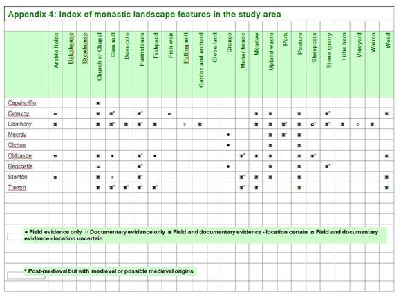
| Appendix 6: Potential sites for earthwork or geophysical survey | |||||||||
|
|
|
|
|
|
|
| |||
|
|
|
|
|
|
|
|
|
| |
| Location | Grid Ref | Description | Condition | Recorded in SMR/ HER/ NMR | Visible | AP | Scheduled | Permission | |
|
|
|
|
|
|
|
|
|
| |
| Bugley field | SO291274 | Possible site of sheepcote | Pasture/ livestock | N | Y |
| N | ? | |
|
|
|
|
|
|
|
|
|
| |
| Cwmyoy | SO299234 | Medieval manorial infrastructure in or around modern settlement | Pasture/ livestock. Settlement | N | Y |
| N | Cwmyoy Farm? | |
|
|
|
|
|
|
|
|
|
| |
|
| SO298228 | Possible fish weir site | Pasture/ livestock, patchy tree cover | N | Y |
| N | Cwmyoy Farm - E bank Coed Farm - W bank? | |
|
|
|
|
|
|
|
|
|
| |
| Cwmyoy | SO300228 | Mill, leates | Pasture/ livestock, patchy tree cover | Y (400408) but no earthworks recorded | Y |
| N | Blaenyoy | |
|
|
|
|
|
|
|
|
|
| |
| Llanthony Priory | SO288278 | Tithe Barn/ Outer Court/ Trackways | Pasture/ livestock | Y (306272), earthwork survey already carried out | Y | Y | Y | CADW/ Court Farm | |
|
|
|
|
|
|
|
|
|
| |
| Llanthony Priory | SO288277 | Fishponds | Farm outhouses,camping field | Y (01732g), earthwork survey already carried out | Y | Y | Y | CADW/ Court Farm | |
|
|
|
|
|
|
|
|
|
| |
| Llanthony | SO286277 | Mill ponds, leate etc | Pasture/ livestock, boggy ground, scrub | Y (01735g) | Y | Y | N | Mill Farm - spoke to farmer, ok to get access | |
|
|
|
|
|
|
|
|
|
| |
| Maerdy | SO247334 | Possible grange site | Ruined farmstead. Pasture/ livestock, boggy ground | Y (9411, 9415) | Y |
| N | ? | |
|
|
|
|
|
|
|
|
|
| |
| Neuaddlwyd | SO285252 | Possible lynchets, building platforms and holloway | Pasture/ livestock, steep ground | N but no earthworks recorded | Y |
| N | Neuaddlwyd Farm | |
| Olchon grange site | SO274328 | Medieval grange site - possibly associated with Llanthony Priory | Extensive ruins. Rough pasture on steep and inaccessible hillside | N - but recent investigation and earthwork survey | Y | Y | N | ? | |
|
|
|
|
|
|
|
|
|
| |
| Oldcastle | SO325245 | Medieval manorial infrastructure at modern farmstead. Earthwork mound fortified dwelling site? | Farmstead, scrub covered mound | Y (01603g) | Y |
| N | Oldcastle Court Farm | |
|
|
|
|
|
|
|
|
|
| |
| Oldcastle mill | SO327238 | Possible site of medieval mill and millponds | Pasture/ livestock, some boggy ground | N | Y |
| N | ? | |
|
|
|
|
|
|
|
|
|
| |
| Redcastle/ The Castle | SO317236 | Possible site of manorial or grange complex and church. Ruined enclosure and buildings. | Bracken on rough ground on top of ridge | N | Y | Y | N | National Park land | |
|
|
|
|
|
|
|
|
|
| |
| Stanton | SO312214 | Medieval manorial infrastructure at modern farmstead | Farmstead, pasture/ livestock | Y (01614g) but no earthworks recorded | N |
| N | Stanton Manor Farm (farmer lives elsewhere; spoke to mother who lives there) | |
|
|
|
|
|
|
|
|
|
| |
| Trewyn | SO329229 | Site of medieval chapel and other visible earthworks | Parkland , pasture/ livestock | Y (01632g) earthwork survey now carried out | Y |
| N | Trewyn House and adjoining fields owned by Trewyn Farm | |

| SI1: Documentary records of Llanthony Priory estates and holdings |
The following is a summary of documentary records of the estates and holdings of the Priory, including their post-Dissolution ownership.
Note:
q Holdings in the study area are indicated in bold italics .
q Names are recorded in their modern form with contemporary forms in brackets where they differ.
q Where a date is provided, this is the first recorded date of the estate or holding being granted to the Priory
q ? indicates location not known, because there is no trace of this or a similar name on the modern and historic maps for the study area.
q Historic county for each item indicated by *Monmouthshire, #Herefordshire, **Brecknockshire.
q The extensive holdings in Ireland are excluded from this summary.
| Miscellaneous recorded grants of property and holdings to Llanthony Priory (Bradney, 1907; Rhodes, 1989; www.cpat.org.uk/ ) |
Manor of Cwmyoy * granted to the Priory by Hugh de Lacey in c1108.
Cusop church # given to the Priory by Ranulp de Baskerville before 1141
Widemarshmoor manor #, Hereford 1147.
Manor of Foxley # given to the Priory by Ralph de Baskerville during the reign of Richard I.
Churches and tithes of Eardsley #, Yazor # and Stretton # granted to Priory by Ralph de Baskerville during the reign of Richard I.
Patronage of Brinsop # given to Priory in approx. 1350 by one of the Brunshope family.
Llanelieu Court ** set up as a monastic cell of Llanthony.
| Monasticon Anglicanum – Sir William Dugdale (Rhodes, 1989) |
Llanthony Prima priory and mill * 1108
Yarsop manor # 1155
Cwmyoy manor and Honddu fish-weirs * 1199
Eardisley church and lands # 1199
Stretton Sugwas chapel # 1199
Oldcastle manor * 1279
Redcastle manor * 1279
Llangorse lake, fishing rights ** 1287
Llancillo church # c1331
Clodock church # c1331
Walterstone manor # c1331
Cwmyoy church * c1331
| Calendar of the Charter Rolls volume I, Edward I 1233 (Public Records Office, 1903) |
“Grant to (the church of St Mary and St) John the Baptist, and the regular canons of Lantonay in Wales of divers grants, pursuant to a charter of King John (of 1199)” (Rotuli Chartarum, 7).
| Calendar of the Charter Rolls volume II, Edward I 1284 (Public Records Office, 1906) |
“Grant to the prior of Llanthony in Wales…of free warren in all his demesne lands in the vale of Llanthony * , Ewyas #, Canon Frome # and Falleye in South Wales”.
| Taxatio Ecclesiastica 1291 – taxes paid by Llanthony Priory (Ayscough, S and Caley, J 1802) |

Translations by Rhodes (1989), Robinson (1980) record:
| Holding | £ | s. | d. |
| Llanthony Priory * St Clodock # Cwmyoy * Llanveynoe (Landefylion) # Newton # Brinsop chapel # Kenderchurch (Kentestre) church and Howton meadows # Stokesay, tithes (Shropshire) Ullingswick, tithes # Bishop’s Frome church and vicarage # Eardisley (Erdesleye) church and vicarage # Langaram church # Orcop church # St Kenedr church # Stanton Lacy church and vicarage # Weobley church and vicarage # Yanefare church and vicarage ? | 13 20 2 2 1 ? ? ? ? ? 1 ? ? ? ? ? 0
| 15 - - - - ? ? ? ? ? 0 ? ? ? ? ? 6 | 4 - - - - ? ? ? ? ? 0 ? ? ? ? ? 6 |
| Calendar of the Charter Rolls volume III, Edward II 1325 (Public Records Office, 1908) |
Confirmed earlier charter of Walter de Lacy (Lord of Ewyas 1189 – 1234):
“Walter de Lacy, son of Hugh de Lacy, gave to St. Mary and the church of St John the Baptist of Llanthony Prima and the canons there…all the valley in which the said church is situated to wit on the side of Kevencassec and Askaresweye and along the Ruggesweye up to Autefyn and on the side of Haterel from the land of Seisel son of Gilbert by the Ruggewey to the bounds of Talgarth…”
| Valor Ecclesiasticus 1535 (Caley and Hunter, 1814) |
|
Translations by Rhodes (1989, 2002), Robinson (1980):
Holdings administered from Llanthony-in Wales:
Eardisley church, rectory and land # Tenement and a mill in Widemarsh Street, Hereford # Llancillo church # Llanveynoe, tithes of Olchon # |

Clodock (Ewias Lacy) church and rectory #
Oldcourt church #
Newton church, rectory and manor #
Peterchurch, tithes of Snodhill #
Rowlestone church #
Walterstone church and rectory #
Yazor church #
Foxley manor #
Kenderchurch rectory #
Abergavenny, a tenement by the north gate *
St John the Baptist rectory *
Manor of Honddu Slade *
Cwmyoy church *
Oldcastle church and rectory *
Oldcastle manor *
Redcastle (Pentwyn) church and rectory *
Redcastle manor *
St Martins chapel, Trewyn *
Stanton manor *
Manors formerly of Llanthony-in-Wales, administered after 1481 from Llanthony-by-Gloucester:
Burghill #
Canon Frome #
Fawley in Fawnhope #
Llanwarne #
Stanton Lacy (Shropshire)
Widemarsh Moor in Hereford #
| Value of the revenues of Llanthony Priory at the Dissolution (Bradney, 1907) |
| Holding | £ | s. | d. |
| Llanthony (Llanthonia), the site and demesne lands * | 5 | 10 | 10 |
| Cwmyoy (Comyowte), manor, etc. * | 47 | 2 | 0 |
| Cwmyoy (Comyowte), perquisites of court * | 0 | 6 | 8 |
| Stanton (Staunton in Guenth), rent of customary tenants * | 2 | 7 | 4 |
| Red Castle (Rebeum Castrum), manor with rectory * | 5 | 10 | 0 |
| Abergavenny, rent of tenants * | 0 | 1 | 6 |
| Oldcastle (Oldecastell), corn, etc. * | 2 | 12 | 0 |
| Oldcastle (Oldecastell)* and Walterstone #, farm of the rectory | 0 | 17 | 6 |
| Cwmyoy (Comyowte), St Martin * ; Ewyas Lacy, St Clodock (Cledock, Clydach) #; Tre-wyn, chapel of St Martin *# ; farm of tithes | 12 | 0 | 4 |
| Foxley, manor # | 5 | 3 | 0 |
| Newton , manor # | 5 | 3 | 0 |
| Howton (Houghton), farm of meadows # | 0 | 6 | 2 |
| Widemarsh Street (Widmarchstrete), Hereford, farm of tenement, mill etc. # | 1 | 10 | 0 |
| Eardisley (Edersley), farm of the rectory # | 7 | 0 | 0 |
| Oldcourt (Ouldecourte), farm of the rectory # | 3 | 6 | 8 |
| Rowlston (Rolleston)#, Llancillo (Llansilow) #, farm of the tithes | 0 | 13 | 4 |
| Newton , farm of the rectory # | 0 | 13 | 4 |
| Kenderchurch, farm of the rectory # | 0 | 16 | 8 |
| Pen-y-parc (Penparke), Snodhill (Snothill), part of the tithes # | 1 | 15 | 0 |
| Ffwyddog (Feotheck), part of the tithes *# | 0 | 12 | 2 |
| Whitewall, part of the tithes # | 0 | 4 | 0 |
| Olchon (Oulgham), part of the tithes # | 1 | 5 | 8 |
| Trewern in Ewyas Lacy, part of the tithes | 1 | 3 | 4 |
| Longa Villa in Ewyas Lacy, part of the tithes # | 2 | 6 | 8 |
| Nethersfield (Netherstfeld), part of the tithes # | 1 | 10 | 4 |
| Fossecombe in Ewyas Lacey, part of the tithes # | 1 | 5 | 8 |
| Burybarn in Ewyas Lacy, part of the tithes # | 2 | 11 | 4 |
| Trelandon in Ewyas Lacy, part of the tithes # | 0 | 14 | 0 |
| Over Brinsop and Nether Brinsop, part of the tithes # | 1 | 17 | 4 |
| Yazor, part of the tithes # | 1 | 17 | 4 |
| Stretton, part of the tithes # | 0 | 7 | 0 |
|
|
|
|
|
| Values of the temporalities and spiritualities | 112 | 0 | 5 |
| Reprises | 12 | 1 | 4½ |
| Remaining of clear value | 89 | 19 | 0½ |
| List of the lands of dissolved religious houses (List of Ministers Accounts Part II, Henry VII and Henry VIII) |
Llanthony Prima (Lanthonia) and Cwmyoy (Comyowte) *
- Site of the priory or cell and lands
- Watermill and cottage near the priory
Site of the manor of Cwmyoy (Comyowte) in Honddu Slade (Hetheneyslade) with demesne lands, tithes and rents of the manor. Perquisites of court *
Rents in Stanton (Staunton in Guenta – Gwent?) *
Manor and rectory of Redcastle (Rebeum Castrum) *
Tenement near the north gate of Abergavenny *
Site of the manor of Oldcastle (Oldecastell) and demesne lands *
Rectories of Oldcastle (Oldecastell) and Walterstone (Waterston) # with the chapel of Hailewen?
Rectories of the parish churches of St Martin in Cwmyoy (Comyowte) *, Clodock (St. Cleodoc in Ewyas Lacy) #, and the chapel of St. Martin in Trewyn *
Manor of Foxley, perquisites of court #
Manor of Newton, perquisites of court #
Meadows of Howton (Houghton) #
Tenement and watermill in Widemarsh Street (Widmarchstrete), Hereford #
Rectories of Edersley #, Oldcourt (Oldecourte) #, Rowlestone (Rolleston) and Llancillo #, Newton # and Kenderchurch #
Portions of tithes in:
Pen-y-parc Snodhill (Penparke Snottill) #
Feothek ?
Whitewall #
Olchon (Oulgham) in Ewyas Lacy #
Trewern in Ewyas Lacy #
Longa Villa in Ewyas Lacy #
Nethersfield (Netherestfeld) #
Fossecombe in Ewyas Lacy #
Burybarne in Ewyas Lacy #
Trelandon in Ewyas Lacy #
Over Brinsop (Overbrinshop) #
Nether Brinsop (Netherbrinsop) #
Yazor #
Stretton #
| Grant by Henry VIII to Sir Nicholas Arnold on Dissolution, 1538 (Bradney, 1907) |
| Manors |
Lordship and manor of Llanthony (Lanthonia) *
Lordship and manor of Cwmyoy *
Lordship and manor of Oldcastle (Oldecastle)*
Lordship and manor of Walterstone #
Lordship and manor of Newton #
Manor of Stanton (Staunton) *
Manor of Red Castle (Rubro Castro) *
| Churches and chapels |
Rectory and church of Oldcastle (Oldecastle)*
Rectory and church of Walterstone (Walterston) #
Rectory and church of Newton #
Rectory and church of Kenderchurch (Kendchurch) #
Rectory and church of Eardisley (Erdisley) #
Rectory and church of Overland #
Rectory and church of Netherland #
Rectory and church of Rowleston (Rouldstone) #
Rectory and church of Llancillo #
Rectory and church of St Martin in Cwmyoy *
Rectory of St Cattwg in Ewyas Lacy #
Chapel of St Martin in Tre-wyn (Trewin) *#
Rectory and church of Red Castle (Rubro Castro) *
Rectory and church of Capel-y-ffin **
| Tithes |
Pen-y-parc (Penpark) #
Ffwddog (ffothiog) *#
Whitewall (Whitwall) #
Olchon (Olghon) #
Tre-wyn (Trewin)? *#
Longtown (Longa Villa) #
Nether Escley #
Ffoscomb #
Bury Barn and Trelandon (Bery Barn) #
Ewyas Lacy (Ewias Lacy) #
Brinsop (Brinsope) #
Nether Brinsope (Brinsope) #
Yazor and Stretton #
| Particulars of the sale of the lordship and manor of Tre-wyn, 1775 (Bradney, 1907) |
Property | Acreage | £ | s. | d. |
| Trewyn (Lower Trewyn)*# Smith’s shop and house *#Trewyn Farm (Upper Trewyn) *# Mill and premises *# The Castle or Pentwyn fort? (Castle on top of the hill) *# Penbidwal (Penbiddle) * Werngounsel * Pwll-y-wern * Pentwyn *#Total Enclosed land of the lordship (demesne) * Common * Chief rents and casual services | 135 - 73 14
4 201 84 37 71 622 310 74 | 180 3 30 40
2 80 30 13 18 413
10 | 0 0 0 0
0 0 0 10 0 10
| 0 0 0 0
0 0 0 0 0 0 |
| Particulars of the sale of Cwmyoy, Llanthony and Llanvihangel estates, 1799 (Bradney, 1907) |
It should be noted that the locations of a number of the farmsteads listed in the 1799 document have not been identified.
Property | Acreage | £ | s. | d. |
| Manors | ||||
Cwmyoy *Llanthony *Stanton * Redcastle * Oldcastle * Triley, manor, mill and rents * Total: |
4285 |
420 120 2278 |
0 |
0 |
| Farms | ||||
Cwmyoy *Oldcastle *Total: |
1956 |
27 |
1 |
4 |
| Perpetual curacies | ||||
Cwmyoy *Capel-y-ffin ** Oldcastle * Walterston # Michaelchurch # Rowlston # Llancillo (Llansilow) # Kenderchurch # |
- - - - - - - -
|
- - - - - - - -
|
- - - - - - - -
|
- - - - - - - -
|
| Freehold estates in Llanfihangel | ||||
| Llanfihangel Court * Pen-y-dre * Skirrid (Scyrrid) Fawr mountain and the Arwallt * Pen-y-bont *Queens Head Inn * The Coal Pit * Bryn-Arw * | 177 129
332 124 - - - |
|
|
|
| Farms in Cwmyoy manor (12,000 acres) | ||||
Court Farm (Llanthony Court) and mill *Great Llwygy (Llwygu) * Little Llwygy (Pen-Llwygu) * Tre-fedw * Llwyn-celyn * Gaer (Ty’r-gaer) * Pen’r-heol *Coed farm (Ty’n-y-coes) * Neuadd * Tyle (Tylau) * Cwmyoy farm * Perthi-crwn (Perth-y-con) * And Ty-canol * Blaenyoy (Blaen-yoy-fach) * Pen-y-wern * Slotog * Pentre-bach * Rhyd (Rhyd-ynow) * And Noyaddllwyd (Neuadd-lwyd) * Ty-canol * Weild (Weeld) * Meas-y-Beran * Wirral (Whirrall) * Graig-ddu (Creigiau-duon) * | 260 117 13 240 148 17 6
200 97 159
138 45 55 6 3 36
100 133 111 28 42 | 132 45 1 110 70 6 4
65 30 150
70 15 30 5 4 25
46 50 56 14 17 | 0 0 15 0 0 0 0
0 0 0
0 0 0 0 4 0
0 0 0 0 0 | 0 0 0 0 0 0 0
0 0 0
0 0 0 0 0 0
0 0 0 0 0 |
| Troed-rhiw-mon (Troed-rhiw-maen) * Dyer’s mill and small farm near Llanthony mill * ? Cae Howel * Gunter’s * ? (near Wiral?) Dinas Arthur * And Ty’n-y-wern * Cyttre (Cuttrey) * And Dol Alice (Dolau) * Maes-y-ffin (Maes-y-felin) *
| 59
39 15 9 18
48
38 | 20
20 9 8 8
21
15 | 0
0 6 0 0
0
0 | 0
0 0 0 0
0
0 |
Farms in Cwmyoy manor let on leases for life (i.e. life tenancies)Ty’r-onnen *Vision (Ty’n-y-coed) *Ty-canol * Ty-isaf * Llyn-on (Steven’s land) * ? John Powell * Ty-bach * Sible Perrot * Ty’n-y-drain ** ? Cae’r-dringol ** Troed-rhiw-glas * Ty-hwnt * Trevelog (Tafolog) * Pen-beili-glas * ? Caer-waen * Pen-llinau (Pen-lan) * Deri-duon * Sychtre (Sychdre-usaf) * Sychdre-isaf) * Troed-y-rhiw-groes * Pen-y-worlod * Dol-gilbert * Saunders land * Pen-castell * Nant-y-carn * Ty-cwm (Nef) * Heol-y-parc *Nant-y-gwyddel *? Tylau * Loxidge (Loxid) * Siarpal * A cottage* Wiral (Whirral) * Ty-isan (Ty-isaf) * ?Ty-uchaf * Sunny bank (Gwain-llydan) * ?Cae-brink * Graig-ddu * Footway * Ty-draw * Troed-rhiw-wen (hen) * Hwlwm (Yr heol-lwm) * Ysgubor-newydd and smith’s shop * Upper Henllan (Hen-llan) * Henllan-uchaf * Lower Henllan * Coed-y-cerrig * ? A house on the Gaer *
|
19 99 21 38 50 47 6 26
17 23 52 49 19 23 23 11 16 21 1 32 6 25 7 40 26 18 66 2 2 61 0 6 47 28 8 2 25 52 14 52 9 33 56 38 43 36 26 5
|
0 2 0 0 2 6 0 0
0 0 2 7 0 2 0 0 0 0 0 0 0 0 0 0 1 2 2 0 0 0 0 0 0 0 0 0 0 0 0 0 0 0 0 0 0 0 0 0
|
2 0 2 9 0 10 1 4
2 10 0 10 10 10 4 2 2 2 1 10 1 4 1 8 1 8 0 1 5 17 5 1 6 8 1 1 3 6 6 6 1 10 10 9 10 2 4 1 |
0 0 0 0 0 0 0 10
2 0 0 0 0 0 4 0 10 2 0 1 4 4 4 0 0 0 0 0 0 10 0 0 0 6 6 0 0 6 0 6 0 0 0 6 0 2 0 0 |
DittoDitto? Hendy on Hattrel Hill * Pont-Rhys-Powell * Ty Charles * Blaen-yoy-fawr * ? (near Ty Charles?) Tir-serth * Ty-hwnt-y-bwlch * ? Pen-y-pistyll * Daren-isaf (The Darren) * ? Llygad-yw * Pentre-bach * The Birches (The Fedw) * Daren-uchaf (The Darren) * Troed-rhiw-gou * Rhyd-rwnw * Daren-ganol (The Darren) *Woods *
| 11 25 1 6 28 46 8 45 0.3 35 9 22 40 35 62 40 21 327
| 0 0 0 0 0 0 0 0 0 0
0 0 0 0 0 0 | 1 3 5 1 2 12 2 19 1 9
6 4 4 11 10 2 | 0 6 0 0 0 8 0 10 0 0
6 4 4 10 6 2 |
| Farms in Oldcastle manor | ||||
Oldcastle Court (The Court) *Glandwr (Landwr) *Ty-canol *NantyMair *Lower Clydd (Clydd-isaf) *Stanton meadow *
| 337 42 60 108 61 7 | 236 52 25 57 36 13 | 0 10 0 0 0 13 | 0 0 0 0 0 0 |
| Farms in Oldcastle manor let on leases for life (i.e. life tenancies) | ||||
Upper Clydd (Clydd-uchaf) *Pen-y-worlod *Pen-yr-heol *Erw-serth * | 64 66 8 3 | 0 0 0 0 | 12 15 3 4 | 0 3 0 0
|
| Llanthony Estate (Tithe Apportionment Schedules) |
| Cwmyoy (Lower and Upper), 1852 |
Total land owned by Reverend Landor (Llanthony Estate) = 3369 acres
Total land in cultivation in Cwmyoy Parish = 4492 acres
| SI2: Glossary of ‘topographical’ and other Welsh words in place and landscape feature names |
(After Coxe, 1801; Davies, 1967; Davies, undated; Knight, undated; Lewis, 1849; Lewis, 1960; Mee, 1951; Owen, 1998; Wade, 1909)
| Aber confluence, moutb of river, smaller body of water in larger e.g. stream into river Ach,Uch or Uwch upper, above, higher Ael edge of a place Afon or Avon stream, river Allt or Gallt coppice, wood, woody cliff, steep ascent, side of hill Ar upon Aw water Bach or Fach little, small Ban or Bann high, tall, lofty Bant hollow, sinking in the ground, valley Bedwen, Bedw or Fedw birch tree(s) Beili bailiff Bettws place of moderate temperature between hill and vale, related to a monastery (derived from Latin Abbatis?) Beudy cow-house Blaen or Blaenau end, head of valley, source of a river, highland country Bôd abode, dwelling, habitation Bre hill, promontory or peak Brêch or Brach spot, spotted Briw broken, rough Bro a country, a vale, cultivated land Bron breast, slope of a hill Bryn mount, hill Bu cow, ox, cattle Bugail shepherd or herdsman Bwa bow Bwch buck Bwlch pass Bychan little Byddin band or troop, army Byrr or Pyr lord Cadarn strong, powerful Câd Nant stream, or the glen of the battle Crannel or Grannell river from Gran, shelving or precipitous Cregrina or Cruginfa from Crugyn, small knoll and Fa, place Craig or Graig rock, crag Croes or Crwys or Groes cross Crûg knoll, tump, mount, barrow, heap of stones and of earth, fortified mount Crwn round Cû lovely or pleasant Cwar quarry Cwm valley, dale Cwysau furrows Cyd with, junction Cylch circle, circuit Cyll or Gyll hazel-trees Cymmer confluence of rivers Dan under, below Darn piece Darren rocky hillside or precipice Dau two Dê or Dehau south Degar ten acres Derw oak Dewi St David Din or Dinas fortified place or hill, city Discoed or Is Coed beneath the wood Dol meadow Draenen wood Drain thorns Dringal sorrel Dringo or Dringad climb Du or Ddu black, dark Dwfr or Dwr water Dwyer two acres Dy see Ty Dyfroedd waters Dyffryn or Dyfr Hynt course of the waters Dylwyf fire-wood, fuel Dylif overflowing, flood Efengyl gospel Eglwys church Eithin gorse, furze Goch see Coch Graban corn marigold, vineyard Graig see Craig Grannel see Crannell Groes see Croes Grwn murmuring Gwaelod bottom Gwald border Gwar neck, back Gwâr mild, gentle Gwartheg cows Gwastadedd plain Gwaun, Gweirlodd or Waun meadowland, down, moorland Gwedd an aspect Gwely landholding system on upland areas based on hereditary family group Gwen or Wen white, fair, pleasant Gwern or Wern swamp, watery meadow, alder tree Gwill swift Gwiwer squirrel Gwrth against, opposite, by, close to Gwydd underwood Gwyllt wild, untamed, savage Gwyn, Gwen or Wyn white, fair, clear Gyll see Cyll Hâf summer Hâfod summer dwelling Helygen willow or sallow tree Hen old, ancient Heol road Hir long Hon easy, pleasant, quiet Hwnt beyond, away, aside Hynt journey, way, course Is beneath, lower, inferior Isaf or Isa lower, lowest Le or Lle place Llan sacred clearing, church, enclosure, village, meeting place Llannerch glade Llawr ground, floor of a building, the earth Llêch slate, flag, broad flat stone Onnen ash-tree Onn plural Or border, the edge, the coast Pawl pole, pale, stake; also Paul Pabell tent, pavilion: Pebyll plural Parc park, field Pant see Bant Pedeirer four acres Pen top, summit, end, head, promontory Penial capital, chief Pentre village Perthi hedges, bushes Pill creek Plwyf people, the common people anciently; parish Poeth burnt Pont bridge Porth gate, door, haven Prysg copse, underwood Pumer or Pimar five acres Pwyll ditch, pool, pit Rag or Rhag commanding Rhaiadr cataract Rhiain maiden, virgin Rhiw slope, ascent, side of hill Rhodwydd open course Rhos upland pasture, moorland, moist large plain, marsh Rhûdd red, ruddy Rhyd ford Rhydd free, at liberty Bôd Rhydd freehold Rhyn mountain, hill or promontory: Rhynion plural Sant saint Sarn causeway, pavement Scgbor or Scybor see Ysgubor Serth steep Sether or Sithar seven acres Steni see Ystany Stow settlement Swydd lordship, office, service with respect to tenure, jurisdiction, shire Sych dry Ynn see Onn Ynys island, rising ground Ys below Ysceifiog hunting-ground Ysgubor barn, granary Ysgwyd shield, buckler Ysgwydd shoulder Yspytty hospital, almshouse Ystan spreading Ystrad vale, street or paved way Ystum situation, figure, bending Ywen or Yw yew-tree(s) | Cae or Gae field, hedge, enclosure Caer or Gaer wall or mound for defence, fort, city Cain white, beautiful Calch lime Cam or Gam crooked, bent Canol or Ganol middle Cantref a hundred of a shire; a district consisting originally of a hundred dwellings; from Cant, a hundred, and Trêf, a habitation Capel or Cappel chapel Carnau cairn Carreg or Cerrig stone or stones Carw hart or stag Carog brook Castell or Gastell castle Cefn or Gefn ridge, back, promontory Ceiliog or Geiliog cock Cell cell, grove Celli grove, wood, coppice of hazel-trees Celyn holly Chwarel quarry Chwecher or Whecher six acres Ci or Cwn dog, hound Cil or Gil retreat Clâs cloister, pre-Norman religious house Clawdd or Glawdd dyke, trench, bank, fence Clegyrog rocky, rugged Clydogau sheltered places Clydach rocky stream Cnup lump, knob Coch red Coed or Goed wood Collwyn grove, coppice of hazel-trees Cornel corner Cors marsh, bog Enwyn buttermilk Erw acre Esgob bishop Fâ, Fan or Man place Fach see Bach Faes or Maes field, meadow, ploughland Fain or Main boulder, stone or long, narrow Fair or Mair St Mary Fan peak Fawr or Mawr great Fedw see Bedw Ffermdy farmhouse Ffraed St Bride, Bridget Ffîn boundary, limit Ffordd way, passage, road Ffynnon fountain, spring, well Figen or Fign or Migen or Mign mire, mossy mountain, bog Fihangel or Mihangel the angel Michael Foel bare-topped hill Fron hillside Fynydd or Mynydd mountain Gae see Cae Gaer see Caer Gallt see Allt Gam see Cam Ganol see Canol Garn cairn or pile of stones Garth hill, ridge, promontory, close, enclosure Garw through, course Gastell see Castell Gefn see Cefn Geiliog see Ceiliog Genau mouth, pass between hills Gil see Cil Gl |
Ref: rs_lty_0002