
Title: | Research paper: The Manor of Trescaylon |
Date: | Up to 1705 |
The Manor of Trescaylon
By Nina Wedell
July 2009
Introduction
A place in Clodock called something like Trescaylon was once a ‘manor’ or ‘barony’ with a castle. It lay in the vicinity of Hunthouse Lane, the road leading from Clodock church towards Walterstone and Llancillo, and was one of a number of feudal sub-manors planted here and there across the much larger Lordship of Ewyas Lacy which covered some ten parishes. All traces of a name similar to Trescaylon (the spelling adopted here) have been lost locally, though from ancient documents the general location of the property by or near Hunthouse Lane is clear. Today a number of farms border the lane for about 1½ miles: Welsh Hunthouse, and Great, Middle and Lower Hunthouse. The sub-manor would have been on land now held by one or more of these farms on the slopes of Mynydd Merddin. This paper pieces together evidence for its origin and location.
Location of Trescaylon in the general area of Hunthouse Lane |

Key documents in the search are manorial surveys carried out when a new owner acquired a moiety, or share, of the Lordship of Ewyas Lacy, which had been split since the 13th century when two sisters, Maud and Margery de Lacy, were co-inheritors[1] . The feudal notion of a ‘moiety’ was partly a sharing of revenues from taxes of various kinds paid by landholders throughout the Lordship, though it could involve some geographical claims whereby separate lands were earmarked specifically by one of other of the co-sharing Lords of Ewyas Lacy. Trescaylon was one such area claimed by subsequent generations from Maud’s lineage. The moiety belonging to Maud devolved to the Mortimer family and then to King Edward IV through inheritance. Thereafter this moiety remained with the Crown until Elizabeth I granted it to Robert Dudley, Earl of Leicester.
In 1566 a manorial survey carried out for Dudley, as a new (co-sharing) Lord of Ewyas Lacy, refers to Trescaylon, as do three later surveys for the same moiety: in 1653 a survey for Thomas Harrison who during the Commonwealth period ‘bought’ this moiety for five shillings; in 1667 a survey for Sir Trevor Williams who, with others, regained the moiety at the restoration of the monarchy; and in 1705 a survey for John Jeffreys who bought or otherwise acquired the moiety. These four surveys are significant resources, though many other documents contribute to the emerging picture of Trescaylon. For convenience, all will be referred to either by date, with source details given in the references, or by the shorthand term ‘Dudley/Jeffreys moiety’ to reflect this sequence of ownership.
An entry in the 1566 survey can serve as an introduction. The inventory of properties notes that
|
| Simon ap Harry esq holdeth the barony of Trescailand in Longtown of the sd Earl paying the yearly rent of 13s 9d ob [½d] but by what service they know not.[2] |
Brief as it is, this entry would have been meaningful to local people who would recognise both the person and place referred to as well as a number of social innuendos. Simon ap Harry (died 1573) was a major local landowner within and beyond Ewyas Lacy whose property in Vowchurch, then known as Moore Manor, was a landmark on the boundary of Ewyas Lacy (‘Beginning at Moore manor Simon ap Harry’s house...’). The rank of esquire, derived from medieval squires who owed service to knights (typically military service), identified him as a member of the gentry. Trescaylon would have been a known place name for a general area. It would not have been surprising that Simon ap Harry held land at a distance of some 6 miles from Moore (as the crow flies, and much more through hilly country), since land grants originating with medieval service were routinely bought, exchanged, inherited or acquired through marriage in a patchwork of properties. In 1566, a requirement for service was somewhat on the wane though not entirely discounted, but the payment of a yearly ‘rent’ would have been expected. Sharp eyes would note that Dudley seemed to be claiming the full payment on this particular property. Even though Trescaylon was called a barony, the payment of a yearly rent would have been understood in feudal terms as a sub-manor within the overall jurisdiction of the Manor of Ewyas Lacy (the tenancy-in-chief). While all sub-manors were highly prestigious, the amount of rent paid, in this case 13s 9½d, denoted the rank of this property within the feudal hierarchy of ‘knight’s fees’ (originally for a whole, half or other fraction of contracted service). The location of Trescaylon ‘in Longtown’ did not mean it was in the borough or village, but in the ‘township’ of Longtown which also encompassed a countryside of dispersed farms, commons and wastes in the parish of Clodock. Finally, local people would have understood that the property was freehold; the feudal notion of rent to the tenant-in-chief was a tax which did not preclude outright ownership, which could accordingly be disposed of or inherited.

Reconstruction of the name
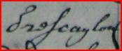
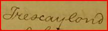
Variants of the name in different documents include Trescailand, Trescaylond, Trewaylan, Trescaylon, Trescailon, Tressalion,Treistaillan and, less obviously, drei Skaylan. As corruptions of the same word, the differences can be accounted for by the phonetic spelling of a Welsh word by either Welsh or English speakers and/or mis-copying. The element ‘tre’ is commonly used for a homestead or farmstead. The remaining part of the word could have originated as a personal name. Or, as is characteristic in Welsh place names, it could refer to local topography or land use: perhaps from tre=homestead or farmstead, ys=lower, cae=field, and lon=lane meaning something like ‘farmstead by the lower field by the lane’. A difficulty with this interpretation is that in ancient documents the word used locally for a lane or road is usually ‘heol’. So, apart from the prefix ‘tre’ there is at present no evidence to support either of these speculations and whatever meaning the word may once have had remains a mystery.
The name Trescaylon is used in association with the name Hunthouse, both clearly being in much the same area. In 1667 there is a reference to ‘Trescaylond (now called the Hunt House)’ and in 1705 to ‘Lands called ye Hunthouse...this lyes within ye manor of Trescailon’. The area covered by Trescaylon is unknown, though it included more than one farm leased or owned by gentry. Might the name Hunthouse throw more light on the origin of the manor? It could be a composite from the Welsh hwnt=yonder or beyond (nothing to do with the sport of hunting), and ws=workplace or storehouse (derived from the English ‘house’), thus suggesting a house with a designated work purpose where ‘yonder’ could mean ‘along the way’ between Clodock and Walterstone and/or Llancillo. However, there is evidence for a quite different derivation of Hunthouse, and I am grateful to Dewi Bowen Williams for sharing this information from his researches. An entry in Records of the Exchequer dating from 1238 (the name of Theobald de Verdun places this entry after 1278) notes, in Latin, that
|
| ‘William son of William le Honte have given granted etc ...[land]...in the lordship of Theobald de Verdun in the tenure of Ewyas Lacy’.[3] |
A later document in English listing dues from Ewyas Lacy c1500 ends with two entries listed one below the other:
|
| It[em] on drei Skalayn – an ox |
Taken together, the two personal names, William le Honte and Adam Hunte, and the association of Adam Hunte with ‘drei Skalayn’, do suggest a possible origin of Hunthouse as a property held over several generations by a family surnamed Hunte. If so, the addition of ‘house’ could be derived either from Welsh or English referring to a farmstead. On balance, the documentary evidence for derivation from a personal name favours this interpretation of the name Hunthouse. By 1667, Hunthouse had become the more familiar place name, and Trescaylon appears to have needed some explanation.

Origin and location of Trescaylon
In the 1667 survey it is noted that ‘there hath been an old castle at Walterstone and another at Trescaylond (now called the Hunt House) now both clearly decayed.’ This confirms the general location in the area of Hunthouse Lane and farms.
The possible site of the castle was reported by the Royal Commission on Historical Monuments in 1931 as an unclassified monument at Great Hunthouse Farm:
|
| Mound, on SE border of the parish, 250 yards SSW of [Great Hunthouse]. It is roughly oval and partly artificial, about ¼ acre in extent, including the defences it has a flat top and is surrounded by a dry ditch except on the NE and E where the scarp abuts on a small stream and on the SW where the ditch is filled in. There are traces of an inner rampart on the W.[5] |
The Herefordshire Sites and Monuments Record [SMR 1464] notes the location at SO 3430 2610 with the further information from Ordnance Survey in 1972 that the feature is ploughed out, and the site vaguely marked by a rise of ground in a generally hummocky arable field.[6]
A third investigation was carried out by the archaeological section of the Woolhope Club in 1995. They reported that
|
| [At Great Hunthouse Farm] we attempted to unravel the confusion caused by two reports of mounds with conflicting map references. Two were seen by Richard Kay in the 1940-50 period [source not cited] and one by RCHM in the 1930’s. We did not find any mounds, although we were told that the field concerned had not been ploughed within living memory...[After returning later in the day:] From the description of the site it should be to the W of the stream, but 250 yards on a SSW bearing would put it E of the stream approx SO 343.261. The area was thoroughly searched on both occasions, and although there are several “humps” in neighbouring fields, none fit the description and distance. There is one mound which could be the second mound of Richard’s? [sic]. The only explanation may be that the RCHM did an incorrect measurement, and that the mound they saw was more than 250 yards SSW of Great Hunthouse.[7] |
From a site visit, at the kind invitation of Mrs Joyce Ellaway, my impression is that the RCHM description is wrong, and that the putative castle site is indeed east of the stream (a deep gulley) in a meadow where it is not difficult to see a mound despite high summer grass. It was confirmed that this field has not been ploughed in living memory (to the 1930s). Other ‘humps’ referred to are also visible in this and adjacent fields, one field being a quarry in the 19th century and into living memory.
Despite the lack of positive proof, the reported ‘old castle’ could have stood in the field investigated. Documentary evidence confirms that Trescaylon and Hunthouse were in much the same area. The existence of a ‘barony’ at Trescaylon with required feudal service supports the notion of a defensive site in that general area, and use of the term ‘old castle’ suggests an early Norman time frame. The castle may have been a makeshift structure and its use as a fortification short term, but it clearly remained a significant feature in local memory.
There is one record, in the 1667 survey, which seems to pin point this location for the castle site on land belonging to Katherine Ychan, widow. Beneath the entry for her freehold property, listed in the Longtown inventory, a memorandum is noted: ‘Q whether in Trescaylon or Walterstone’. The query implies that some sort of recognised demarcation of land relevant to this property was uncertain or missing, presumably between Longtown and Walterstone. One small section of the modern boundary between the two parishes crosses several fields where there is no apparent demarcation of land on either side, and one of the fields is the reputed castle site. This section, shown on the 1840s Tithe Maps for Longtown and Walterstone (and is still on the OS 1:25,000 map today) is the only place where the boundary between the two parishes does not follow a watercourse or road or field boundary, and where the absence of a delineating feature could have caused uncertainty. The nearest existing farm is Great Hunthouse, which seems a likely candidate for the property of Katherine Ychan. The 1705 survey continues the family association: ‘Ruth Hopkine [sic] widow holdeth free one Messuage and Lands called ye Hunthouse...this lyes within ye manor of Trescailon’. As Ruth Hopkins was the daughter of Katherine Ychan, her property a generation later was plausibly Great Hunthouse and included the castle site within its lands.
| Location of Great Hunthouse farm in relation to the parish boundary |

However, Trescaylon clearly held more than one property and unfortunately for later investigators it is sometimes not clear whether differently named persons held different properties or the same property at different times. Such is the case with another landholder, William Phillpotts, Esquire, who in 1705 held ‘all that messuage or farme called the Hunthouse with the lands thereto belonging lying in Cloddock’ which had been leased initially to his grandfather Nicholas Philpotts. It is noted elsewhere that a building leased to Nicholas Philpotts called Hunthouse was ‘very ruinous and out of repair’. The question arising is whether this building was the castle, in which case there would be conflicting options for the owner of the castle site, Ruth Hopkins with a freehold or William Philpotts with a leasehold. Either seem to represent a shift away from the family of Simon ap Harry in following generations.
The Manor of Trescaylan, 16th to early 18th century
The Parry and Vaughan dynasty
When Simon ap Harry held the Manor of Trescaylon in 1566 it was one of various landholdings in Ewyas Lacy belonging to him. In his will of 1573, Simon ap Harry left ‘to my base son John Parry of the Moor, my mannor of Treistaillan, and all other lands in Clodock’.[8] A survey of 1590 by the Lord of Abergavenny, co-sharer of the Lordship of Ewyas Lacy, confirms the inheritance:
|
| John Parry [holds] of the lord half the manor of Trestailan as of his lord of Ewyas Lacy late Simon Parry Esq by military service. [Latin][9] |
Interestingly, this entry confirms that feudal military service was still required. It also shows that in Abergavenny’s view Trescaylon was a shared property, in which he had a half stake as co-sharing lord of Ewyas Lacy. This apparently was not the view of Dudley in 1566 nor subsequent lords in the Dudley/Jeffreys moiety, as will be discussed below.
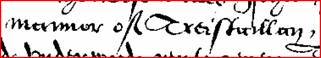
The property later passed to Simon’s great nephew Roland Vaughan, as noted in 1667: ‘The Barony or Manor of Trescaylond in Longtown formerly the Lands of Simon Ap Harry Esq & after of Rowland Vaughan Esq’. Rowland Vaughan (1559-1628) also held Moore Manor( later known as Whitehouse) in Vowchurch[10] and Newcourt in Bacton, the latter a property with additional landholdings in the Ewyas Lacy parishes of Newton, Michaelchurch Escley, Craswall, Llanveynoe and Longtown as well as a number of others in the Golden Valley. He was a member of the Parry and Vaughan families who were interrelated over several generations to form a powerful dynasty of local landowners within and beyond Ewyas Lacy, including the Vaughans of Moccas Court. Rowland Vaughan is locally famous for his ‘waterworks’, a scheme of irrigation in the Dore valley; this and his efforts to boost local industry are described in his book about the project[11] .
It seems that the Parry/Vaughan tenure of Trescaylon may have involved some dispute about how the property related to the Manor of Ewyas Lacy. The survey of 1667 reports that: ‘The Barony or Manor of Trescaylond in Longtown formerly the Lands of Simon Ap Harry Esq & after of Rowland Vaughan Esq and not in the Hands of the Lord of this Manor was formerly held of the Lords of this Manor [emphasis added] by the yearly rent of 13s-9½d.’ Some 28 years later, wording in the 1705 survey notes that the property had reverted back to the moiety of Ewyas Lacy recently purchased by John Jeffreys: ‘The Barony or Manor of Tressalion ...now purchased to the sd Lordship of Ewyas Lacy [emphasis added] was formerly held by the Lords of this Manor...’. Taken together, the very tortuous wording in both surveys suggests that the sub-manor had in some sense been taken over by the Parrys/Vaughans and this was the state of affairs in 1667, but that by 1705 the property had been restored by purchase to the moiety of John Jeffreys as one of the co-sharing lords of Ewyas Lacy.
A de facto loss of Trescaylon may account for the perplexing title given to the survey of 1653 for Thomas Harrison, ‘A Particular of the Manors of Ewyas Lacy, Walterstone and Trewaylon’. Ewyas Lacy was quite different in scale from the other two places, having originated as a tenancy-in-chief , a tier of feudal authority next below the Crown and covering a geographical range of some ten parishes (as they later became), whereas the other named places were sub-manors. In the 13th century division of Ewyas Lacy into two moieties, Walterstone was specifically allocated to the share of Maud de Lacy.[12] In the Dudley/Jeffreys surveys from this lineage, emphasis is laid on a particular claim to land in Walterstone among other general areas of Ewyas Lacy, which in 1667 included ‘the Forrest of Olphon ye Common called Middle Mescoed & Keven Bach...together with Coed Gravel in the Parish of Walterstone’. It seems possible that the specific naming of Walterstone and Trescaylon in 1653 may reflect some threat to the ownership of these places which had not yet been resolved when a share of the Lordship of Ewyas Lacy was inherited by Trevor Williams in 1667, but had been settled by 1705 when John Jeffreys bought this moiety of the Lordship and much of the land pertaining to it. All the places specifically earmarked were undeveloped land or commons, and this may have been the case too in the claim to Trescaylon, perhaps as a property with a significant amount of undeveloped land on the hill slopes.
The Parry/Vaughan dynasty clearly played a major part in local property deals. Under the heading ‘Newcourt’, their landholdings are allocated to a separate inventory in the 1667 and 1705 surveys. The wide geographical range and piecemeal distribution of the properties in several parishes suggest a strongly acquisitive interest. Over several generations the family had considerable local influence[13] : Simon ap Harry’s great grandfather, Henry ap Griffith, was steward of Ewyas Lacy in 1460; his grandfather Myles ap Harry was a local escheater (manager for the Crown) for two years from 1470; and his father Henry Myles was sheriff of Herefordshire in three annual appointments in 1499, 1508 and 1512. Later generations were interrelated with the Scudamores of Kentchurch who had extensive property interests in Ewyas Lacy, and the Cecils of Alltyrynnys whose relation William Cecil, Lord Burleigh, was chancellor to Queen Elizabeth . Blanche Parry, Simon ap Harry’s sister, was chief lady in waiting to the Queen. The specific listing of Newcourt properties coupled with a special claim to Trescaylon may represent an attempt by the Dudley/Jeffreys moiety to curb inroads into the Lordship of Ewyas Lacy from this power block (as much as a concern to forestall the Lords of Abergavenny in rivalry for land and property).
The Ychan family
The surname Ychan appears in the inventory of Newcourt properties in the 1667 and 1705 surveys: in 1667 Howell Ychan, gentleman, held a freehold in Clodock and his wife Katherine Ychan (a widow in 1667, died 1702) held freeholds in Llanveynoe and Longtown[14] . On the whole, the Ychans seem principally associated with Llanveynoe, where Brass Knoll was one of their holdings, and the northern part of Longtown in an area called Penpwllsond. As noted above, Katherine Ychan also held a property at an uncertain location – either Trescaylon or Walterstone. From wills and other correlating records, one of Howell and Katherine Ychan’s daughters can be identified as Ruth Hopkins, who in 1705 was the widow of Phillip Hopkins, and among other lands held a freehold called Hunthouse, which ‘lyes within ye manor of Trescailon’. It is not known if this property was inherited from her husband or from her father. Judging from the previous ownership of Trescaylon by her mother Katherine, this property is arguably more likely to have been inherited from the Ychan side. Ruth Hopkins and her sister Syble Miles inherited other property directly from their father Howell Ychan. Whether he was related to the Vaughans/Parrys is as yet unknown: although a freeholder, Howell Ychan’s status as ‘gentleman’ would have put him a notch down from esquire in the ranking of gentry. He seems to have died by 1667 when Katherine is described as a widow, (although probate papers after his death are dated 1668), which was around the time that Trescaylon was being listed as a barony by Trevor Williams in the 1667 survey. Although the barony was ‘not in the Hands of the Lord of this Manor’ (ie Trevor Williams himself) the identity of the then purported holder of the barony was not given; the last named holder in this survey was Rowland Vaughan who died c1628. All of this hints at an unwillingness to name a successor to that tenure, and may reflect some tensions over rights to revenue at a time when the Ychan family, with its Newcourt associations, held a property possibly including the castle site.
The Philpott family
In the 1705 survey, William Philpott, Esquire, held the lease for a ‘messuage or farm called the Hunthouse with the lands thereto belonging’, which was first granted to his grandfather Nicholas Philpott[15] . The farm consisted of 56 acres, with field names and sizes noted. The date of the original lease is not stated, but as it was granted by Thomas Wyndham the date would be about 1667-70 when Wyndham was granting other leases in Ewyas Lacy. (Wyndham himself had gained this and other properties as a reinstated inheritor after the Commonwealth take-over had ended at the restoration of the monarchy[16] .)
Unlike the Ychans, the Philpotts do not appear in the inventory of ‘Newcourt’ property holders in Ewyas Lacy. Indeed Nicholas Philpott (c1643 -1683) was a major landowner himself, in the parishes of Peterchurch, Vowchurch and Turnastone to the east of Ewyas Lacy in the Golden Valley, and lived at Poston. Although he was active in acquiring property, he or his inheritors appear to have been lax about the upkeep of buildings at Hunthouse and another holding in Michaelchurch Escley. The 1705 survey notes that
|
| one certain Messuage called the Hunthouse now held by Lease by Nicholas Philpotts Esq is very ruinous & out of repair and that part of the building to the sd Messuage or farm belonging are taken down or suffered to fall down for want of reparacion and the other Messuage & buildings the sd Nicholas holds by Lease in Michael Church Escley is likewise ruinous & out of repair... |
This entry comes in an addendum to the survey headed ‘A Supplement to the former Presentment’, which appears to be filling in gaps of information thought to be significant.
Since ruins would not have been an unusual sight and of course were routinely quarried for dressed stone, what might be especially noteworthy about these? Whatever the grievance may have been – perhaps about a change of land use, abandoned or poorly managed land, or even a personal grudge, as much as about the buildings – it does suggest that a ruined building at Hunthouse could have been the castle or a building very near it. The purported castle site should at least be considered a candidate for the property inherited by William Philpotts. If so, the building would have been on land now belonging to Great Hunthouse farm.
Great Hunthouse farm
While the property called Hunthouse was clearly ‘within’ Trescaylon, its size relative to the whole area of Trescaylon is not known. A sale notice in 1808 for ‘Hunt House Farm’[17] , at that time owned by Thomas and James Pitt and occupied by a tenant, gives an acreage of 136a-2r-3p, most of which was in Clodock parish though a portion of 26a-2r-0p consisting of four fields was in Walterstone. There is no surviving plan, but all the fields are named and separate acreages given for each. Special note is made of one field of 9a-1r-0p called Lower Pasture which was in two parishes: 5a-3r-35p in Clodock and 3a-1r-5p in Walterstone. The question arising is whether Lower Pasture might be the same area noted above where the parish boundary crosses a field without a visible demarcation, which is also the area of the reported castle site.
The 1840s Tithe Survey provides an inventory of fields and their acreage as well as a map[18] . At that time Great Hunthouse (mistakenly called Lower Hunthouse in the Tithe Survey) was owned by Thomas Jennings and occupied by William Williams. The farm held a total of 130a-0r-6p, more or less equally divided between Clodock and Walterstone parishes, with 63a-3r-1p in Clodock and 66a-1r-5p in Walterstone. The field formerly known as Lower Pasture is likely to be a field of 11a-3r-38p called Great Meadow straddling the two parishes; of this 8a-3r-32p lay in Clodock and 3a-0r-6p lay in Walterstone (see the location map of Great Hunthouse above). Although the two records do not give identical measurements - the size in 1808 being nearly 9 acres and in 1840 nearly 12 acres - the difference can be accounted for by such factors as the absence of a parish demarcation, different surveyors for two parishes in the Tithe Survey, and/or some adjustments of land use.
As for the farmhouse itself, the Royal Commission on Historical Monuments in Herefordshire (dealing with buildings dating to 1700) includes a brief entry on Great Hunthouse[19] . No date is given for the house but some ancient features are described, including front gables, a number of two-and three-light windows with old wooden frames, some doorways with chamfered frames, and an old roof in the south wing with collar-beam trusses with chamfered and cambered collars. The barn is dated late 17th century.
The subsequent history of Great Hunthouse lies outside the scope of this study, though it can be noted that while a host of documents refer to Hunthouse farms - Middle, Lower and Great, as well as Welsh Hunthouse – and to their owners or occupiers, they are not usually differentiated even in more recent records such as sale notices and trade directories.[20]
Summary and conclusion
Information with a bearing on the origin and history of Trescaylon can be reviewed at different levels of assurance: some well supported, some probable and some possible.
What can be accepted as fact is that a name sounding something like Trescaylon was given in the medieval period to a general area on the slopes of Mynydd Merddin which included properties later known as Hunthouse farms. It was a feudal landholding known as a ‘manor or barony’ which required military service until the late 16th century. Persons named as holders of the barony, Simon ap Harry, John Parry and Rowland Vaughan, were members of an extended family associated with Newcourt and a number of property interests in Ewyas Lacy. Within Trescaylon there was also a castle which had fallen into ruins by the late 17th century.
The level of probability depends on inferences from a range of sources. Several surveys hint at some rivalry in claims to ownership of Trescaylon. It is probable that the Dudley/Jeffreys moiety repeatedly claimed exclusive ownership of Trescaylon which was threatened both from the Abergavenny side, who otherwise shared much of the revenue of the Lordship of Ewyas Lacy, and the Newcourt side who were acquiring and consolidating properties in Ewyas Lacy on a piecemeal basis. This interpretation is supported by similar claims to exclusive ownership elsewhere in Ewyas Lacy, and particularly in the emphasis given to Trescaylon in the title of a number of documents.
It is highly probable that a castle (as some sort of defensive site) known from the written record was the original focal point of the sub-manor. However, the purported location of the castle arguably just passes muster as probable. Although reports from site investigations are confused and/or inconclusive, the visible evidence in 1931 need not be dismissed even if the orientations were wrongly described in a subsequent write-up. The proposed castle site can be tested archaeologically, and pending further investigation can reasonably be regarded as probable.
Unless the castle site is confirmed, Great Hunthouse farm has only a possible connection with the seat of the sub-manor. Persons owning or leasing an unspecified Hunthouse farm, Ruth Hopkins and William Philpott, were each associated with landed gentry active in acquiring property in Ewyas Lacy. Circumstantial evidence suggests a possible connection of each with land that is now Great Hunthouse farm: in the case of Ruth Hopkins, an undefined parish boundary on her Hunthouse property; and in the case of William Philpotts, a ruin on his Hunthouse property. Whether one of these these landholders, or others, can be more securely identified with Great Hunthouse remains for further research.
This study is put forward as a first exploration into the manor of Trescaylon, and in no way is meant to be definitive. Overall, the search has rediscovered a place entirely forgotten in local memory, and gives it an approximate location on the map. But finding out more or less where Trescaylon lay is only part of the interest: more importantly, the documentary evidence reveals a great deal about lingering traditions of feudalism in rights to property; the eventual breakup of a ‘barony’ into multiple properties; and an increasing interest from neighbouring landed gentry in acquiring property in Ewyas Lacy. These themes emerging from Trescaylon can contribute to other settings in the history of Ewyas Lacy.
|
| Acknowledgement I am greatly indebted to Dewi Bowen Williams for contributing much information about place names and spellings from his detailed knowledge of ancient manuscripts, including photographed samples which have been used here to illustrate a few variations of spelling and handwriting styles. |
|
References
1566 Survey : Rental of Ewias Lacy on the behalf of Robert Dudley, Earl of Leicester. Longleat DU/Vol XVII
1625-26 Survey: Survey and Rental of Ewyas Lacy ex parte Henrici Nevil militis, Domini Bergavenny. Gwent Record Office: MAN/A/151/0022 and copy MAN/A/151/0028
1653 Survey : A Particular of the Manors of Ewyas Lacy, Walterstone and Trewaylon. Gwent Record Office: MAN/151/0077. Click here to see a digital image on the ELSG website.
1667 Survey : Survey of the Manor of Ewyas Lacy on the part of Trevor Williams. Gwent Record Office: MAN/A/151/0023. Click here to see a digital image on the ELSG website; click here to see a transcription of the Articles of Inquiry.
1705 Survey : Manor of Ewyas Lacy, survey for John Jeffreys. Herefordshire Record Office: J91/4. Click here to see a transcription on the ELSG website.
For other manorial surveys on the ELSG website, click here
[1] To see the succession of the Lordship of Ewyas Lacy in the two lineages, click here
[2] 1566 survey. Transcription courtesy of Dewi Bowen Williams
[3] National Archives: Records of the Exchequer, Treasury of Receit, Ancient Deeds series A. E40/8638. Transcription courtesy of Dewi Bowen Williams
[4] Bodleian Library, Oxford : MS Rawlinson B 173 fol. 228r. Transcription courtesy of Dewi Bowen Williams
[5] Royal Commission on Historical Monuments: Herefordshire Vol 1. Click here to see the entry on page 191. (This is a large file)
[6] For Herefordshire Sites and Monuments Record number 1464, click here
[7] ‘Investigations in the Walterstone Area, 6 June 1995’. Herefordshire Archaeological News no 64, 1995 p 43 & 48
[8] For the will of Simon ap Harry, click here and go to ‘Symond Parry, of the Moor, Vowchurch, Heref.’
[9] Survey for Lord Abergavenny, 1590. Transcription courtesy of Dewi Bowen Williams
[10] For a history of the Whitehouse estate, click here .
[11] For biographical notes on Rowland Vaughan click here .
[12] Inquisition Post Mortem, 20 Edward I (1291) Click here to see
[13] See Richardson, Ruth Elizabeth ((2007) Mistress Blanche Queen Elizabeth’s Confidante, Logaston Press, Almeley for an account of the Parry family’s local interests and connections over several generations.
[14] Children of Howell and Katherine Ychan (will 1702 ): Noah (will 1679 ); Jane m. James Parry; Syble m John Miles, gent; Ruth m. Phillip Hopkins; Katherine (will 1720 ) m. George Price; Mary m. William Prichard
[15] For the will of Nicholas Philpott, click here and go to ‘1681 Philpot, Nicholas’
[16] For Ewyas Lacy during the Civil War and Commonwealth period, click here . For inheritors reinstated at the restoration of the Monarchy, click here and go to Tredegar 25/147
[17] National Library of Wales: Twiston Davies 3848. Sale Particulars, Hunthouse Farm 1808
[18] For the Tithe Survey of Longtown, click here . Note that Great Hunthouse is wrongly called Lower Hunthouse on the Tithe Map. For Walterstone, click here .
[19] Royal Commission on Historical Monuments: Herefordshire Vol 1. Click here to see the entry on Great Hunthouse
[20] To access documents referring to Hunthouse farms on the ELSG website, click here and enter the search term Hunthouse or “Hunt House”
Ref: nw_lon_3006