
Held at: | British Library |
Reference: | Maps 28. b. 30 |
Source: | British Library Online Gallery/ Exhibitions/ Maps |
Title: | Digital Archive: Map of South Wales and the Border in the 14th century, [SE] by William Rees |
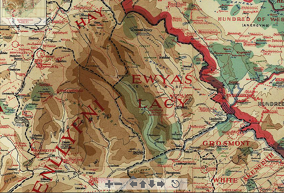
Place name: | Ewyas Lacy |
Date: | 1933 |
Description:
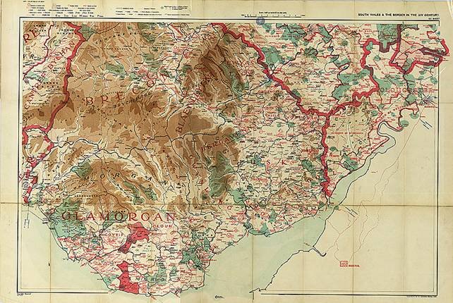
This map was created in 1933 by William Rees, Professor of History at the University of Wales in Cardiff to show his interpretation of the social, political and geographic features of South Wales as they had been in the 14th Century. His work was based on some twenty years of academic research and was published by private subscription through the Ordnance Survey. The original document is one of four sheets accompanied by an explanatory booklet and these are held in the British Library. They are available in the BL Online Gallery; the South East sheet referred to here and showing Ewyas Lacy and the surrounding area is at: http://www.bl.uk/onlinegallery/onlineex/maps/uk/004953638useu1932.html
Higher definition images of the Ewyas Lacy section of the map and the map keys can be downloaded via the following links:
![Ewyas Lacy [North]](/docs/Rees_ELNorth.jpg)
![Ewyas Lacy [South]](/docs/Rees_ELSouth.jpg)
Observations:
The background to the production of these maps and their significance is illustrated by the following contemporary review in a French academic journal:
Etudes Celtiques, vol. 1, fascicule 1, 1936.
[Commentary on William Rees’ maps of South Wales]
This work by the learned professor of the history of Wales at the University of Cardiff consists essentially of four canvas maps, excellently executed, and whose meeting includes the entire South Wales, that is to say the two dioceses of Llandaff and St. Davids. The brief accompanying booklet is intended only to facilitate reading, to prepare for use.
We are often inclined to separate geography from history: some people believe these would be two independent disciplines that could live in ignoring each other. The work of M. Rees proves the contrary; it shows what profit they have in uniting and combining their resources to better understand human activity by considering the land where it developed.
In a previous work, received with just praise (cf. R. Celt .., XLIV, 197), M. Rees had done the work of an historian by exposing the social and political evolution of Wales between the 13th and 15th century. The maps he publishes today illustrate his historical work; they present an exact and direct vision of the transformations that the country has undergone from the point of view of ownership and territorial organization.
The fourteenth century is in Wales a period of transition. Anglicization of the Country, begun with the first conquests and the first encroachments of the see royal, is politically completed in 1282, with the submission finally of the Welsh princes and the death of their leader, Llywelyn ab GrufFydd (cf. R. Celt.> XLIX, 193). But from an economic and social point of view, it continued throughout the following century and did not end really until the sixteenth century, which marks the end of the Middle Ages.
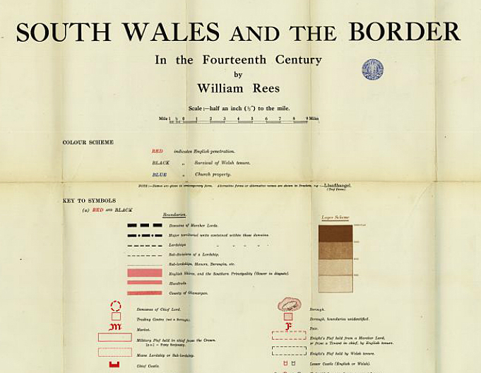
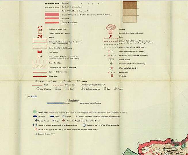
It is in the first half of the 14th century that we can best measure the strength and direction of movement which was to result in the full removal of traditional living conditions. Also Mr. Rees has chosen this period to represent in South Wales the respective position of the old tribal system of British tradition and the feudal system of Anglo-Norman imports. In the absence of maps dating back to such a distant time, he made use of all existing testimonies (charters, documents, stories of historians) to reconstitute the state of the country. He has distinguished by using different colours the places and areas where Welsh customs were preserved [marked in black], those where English customs had penetrated [marked in red] and the lands which belonged to the Church [marked in blue].
The creation of the map needed a considerable amount of work. But we can say that he was rewarded for his efforts because the appearance of the map thus established is striking. From the first glance we realize the infiltration of English uses in the valleys and in the lowlands; on the other hand, in the highlands, in the mountains and inaccessible places, the character of the country has remained Welsh.
The boroughs, which were almost exclusively Anglo-Norman creations - the only exceptions in the South of Wales being Lampeter and Aberafan - formed so many homes of foreign influence: they were centres of commerce, placed at the junction of roads, at the crossroads of communications; this is where the markets and fairs were held, except for a few old fairs, installed on heights along old tracks, Roman fairs such as the Saint-Mary Hill (Glamorgan) or Rhosfair (near Strata Florida). From the 14th century, England locked up the country's economic activity in a very tight network: the outcome of the struggle was fatal; we see it written in advance on the maps.
J. Vendryes
Ref: rs_ewy_0343