
Held at: | Private Collection |
Reference: | rs |
Source: | Original Documents – National Library of Scotland website |
Title: | Digital Archive: Ordnance Survey six-inch Maps; extracts showing the Stations on the Golden Valley Railway |
Place name: | Golden Valley |
Date: | 1886, 1945 |
Description:
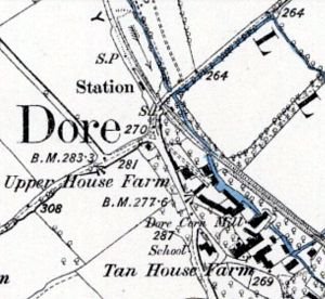
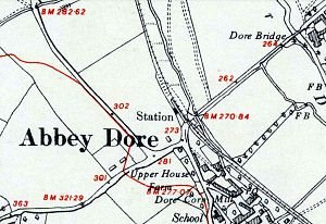
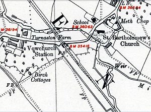
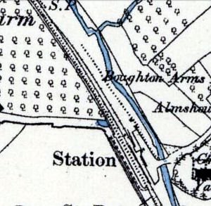
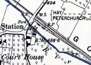
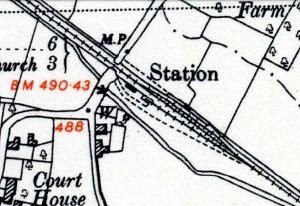
The table below contains extracts of the Ordnance Survey six-inch series maps surveyed in 1886 [published 1887] and 1945 [published 1953] showing the stations of the Golden Valley Railway from Pontrilas to Hay. The maps are shown side by side; the line and stations to Dorstone were completed in time for the 1886 survey, but the 1887 maps show open country at station sites beyond Dorstone because the stations onward to Hay were not completed until 1889. Interestingly, the 1887 map does clearly show the line of the onward route for a short distance out of Dorstone, indicating that some work on the Hay extension had been done by1886.
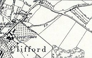
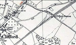
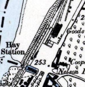
The map comparisons show how the construction of the Hay extension impacted on the previously open countryside around Westbrook, Clifford and Hay. Otherwise the principal track layout differences in nearly six decades of eventful history of the Golden Valley Railway are at Dorstone with a loop and an additional platform to accommodate two-way working through to Hay after 1889, plus changes made during the Second World War at Pontrilas with additional loops and sidings relating to traffic generated by the Elm Bridge Munitions Depot, at Elm Bridge itself with the GVR spur line to a new military rail network inside the Depot, and at Bacton with new sidings in an expanded goods yard.
| Ordnance Survey 6” Series 1887 |
| Ordnance Survey 6” Series 1945 [1953] | ||||
|
|
| ||||
|
|
| ||||
|
|
| ||||
|
|
| ||||
|
|
| ||||
|
|
| ||||
|
|
| ||||
|
|
| ||||
|
|
| ||||
|
|
| ||||
|
|
| ||||
|
|
| ||||
|
|
| ||||
|
|
| ||||
|
|
| ||||
|
|
| ||||
|
|
| ||||
|
|
| ||||
|
|
| ||||
|
|
| ||||
|
|
| ||||
|
|
| ||||
|
|
| ||||
|
|
| ||||
|
|
| ||||
|
|
|


NOTES:
- At Pontrilas, by 1945 the Great Western main line track layout had changed, including an additional loop on the up line linking to the GVR branch, and an additional spur into the goods yard.
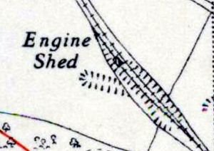
- By 1945 the original GVR Engine Shed had been rebuilt and the map shows a track extension running through the shed and some distance beyond.
- The Elm Bridge Munitions Depot was constructed c.1940 as part of a series of Central Ammunition Depots and sub-depots, and became the primary destination for traffic on the Golden Valley Branch line during the Second World War. The Golden Valley Railway track, bridges and culverts had originally been built only to “light railway” specifications, and so had to be strengthened between Pontrilas and Elm Bridge to carry heavier locomotives and loads. Access to and from the main line rail network was via Pontrilas, which became an important marshalling and transfer point for Elm Bridge traffic The access spur from the main Golden Valley line was situated a few hundred yards north of the Elm Bridge level crossing, and before Abbey Dore station, and fed an extensive military rail network within ‘The Dump’ as it was known locally. Neither the Elm Bridge spur line nor the depot with its internal rail network appeared on any Ordnance Survey maps until 1981, presumably for security reasons. The images shown here of the depot rail links are from the internet at http://www.railmaponline.com .
- At Abbey Dore, the original siding shown on the 1887 map appears to have been removed by 1945
- At Bacton, in 1887 the original Golden Valley line had only a level crossing and a crossing keeper’s cottage. Later a station passenger request halt with platform and shelter was built, and during the Second World War a large goods yard and sidings were constructed, which can be seen on the 1945 map. The site was used during the war for assembling imported American Allis Chalmers tractors
- At Dorstone, the 1887 map shows the Golden Valley line terminates at the station, although there is cleared ground extending beyond for the intended extension towards Hay. The 1945 map shows significant changes to the station and track layout that were made as part of the 1889 Hay extension, including a new ‘down’ platform and loop [disused well before 1945] to permit trains to pass in opposite directions for two-way working.
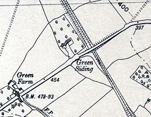
- Green Farm and Siding before and after the advent of the GVR Hay extension; here an embankment has been constructed to take the road up to a bridge over the line, a departure from the usual GVR practice of using [cheaper] level crossings. For a period there was a passenger request halt with platform and shelter here, though it is not shown on the 1945 map.
Observations
Maps courtesy of the National Library of Scotland Map Images website
Ref: rs_gdv_0116