
Held at: | Internet |
Reference: | http://archaeologydataservice.ac.uk/archives/view/phillips_2005/ |
Source: | Internet – Archaeology Data Services [University of York] |
Title: | Earthwork Castles of Gwent and Ergyng AD 1050-1250: St Margarets Earthwork |
Place name: | St Margarets |
Date: | 1050 - 1250 |
Description:
This summary concerning St Margarets earthwork is an extract from a Doctoral thesis by Dr N Phillips, University of Sheffield (2005), entitled ‘Earthwork Castles of Gwent and Ergyng, AD 1050-1250’. This thesis is concerned with the earthwork and timber castles built in the southern March of Wales, addresses the presence of the castles and discusses their roles as weapons of conquest and structures of administrative control.
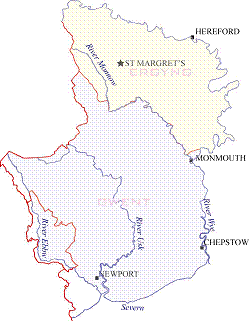
ST MARGARET’S - Grid: SO 35800 33900
Introductory note:
The earthwork at St Margaret’s was one of the sites included on the original search database provided by the Hereford SMR.
Location:
St Margaret’s church can be reached from the B4347, Ewyas Harold to Peterchurch road at Bacton Stud turning left and travelling about 2km to a cross roads then turning right and then right again at the next cross roads.
Description:
The site of St Margaret’s earthwork was searched for but could not be found during the fieldwork stage of this study and so there is no first hand information available on which to make an assessment. Three attempts were made to find visible evidence of this site but all failed, furthermore whilst engaged in a watching brief at the church, it was possible to question a number of the local inhabitants as to the whereabouts of the earthwork but none of those questioned could remember such a mound.
Topographic survey:
No topographic survey was undertaken as the site could not be found.
Strategic position:
It is very difficult to assess a site for strategic position if there is no accurate location for it, therefore the interpretation can be no more than a general observation. As such, the area has no observable natural defence other than a gentle hill slope. The site could, however, have been useful as a lookout point for a watch-tower.
Documentary evidence
Modern reference: HWCM9253
The site is included in the RCHME 1931 inventory as unclassified and the description describes an oval mound 600 yards (0.6km) east/north-east of the church, which stands between 10ft, (3m) and 5ft, (1.5m) above the surrounding land (RCHME 1931. 227). King was also successful in finding the site and described ‘a small heap of earth, the spoil from some fairly modern digging’ which he duly added to his list of reject sites (1983 214).
Interpretation: Possible motte/fortified-site (Unknown)
The interpretation for this site is based on the one piece of documentary record and the SMR listing. The best that can be said for it is that the earthwork may have been a motte and bailey or a later fortified house and a point in favour of the latter is the general topography of the area which has no natural defence and no observable strategic value.
Observations:
The material is copyright by the author, and is reproduced here from the Archaeology Data Service website of the University of York for research purposes under their terms of use
Ref: rs_stm_0176