
Held at: | Private collection |
Reference: | gc |
Source: | Research on Tithe Map schedule |
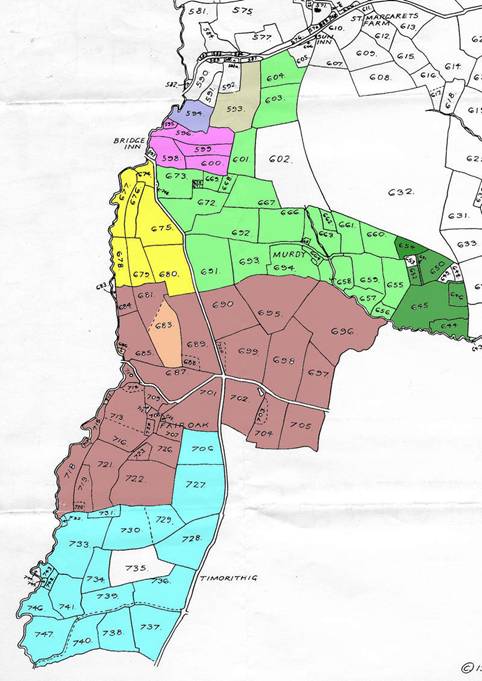
Title: | Some Land owners in part of St Margarets, Map 12 |
Place name: | St Margarets |
Date: | 1844 |
Description:
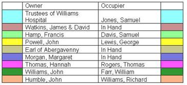
Some properties and their owners in part of St Margarets at the time of the Tithe map of 1844
Property | Owner | Occupier |
Timorithig Farm | Trustees of Williams Hospital | Samuel Jones |
Fair Oak | James & David Watkins | In Hand |
Maerdy Farm | Francis Hamp | Samuel Davis |
Land (plots 678/680) | John Powell | George Lewis |
Land (plot 593) | Earl of Abergavenny | In Hand |
Land (plot 594) | Margaret Morgan | In Hand |
Land | Hannah Thomas | Thomas Rogers |
Land [The Calls] | John Williams | William Farr |
Land (plots 683 & 686) | John Humble | Richard Williams |
--- |
|
|
Part of House (plot 648) | John Williams | Joseph Powell |
Part of House (plot 649) | John Williams | William Johnstone |
House (plot 653) | John Williams | John Puddle |
Land (plot 744) | Daniel Pearce | David Jones |
Plot 686 is a small plot adjoing field 685
Plot 744 is adjoining field 743 and is uncoloured on the map
Field 735 is unlisted
Land 678/680 is part of Newhouse Farm in Newton
Names in brackets [ ] are from other sources
|
to see associated maps click here
Observations:
None
Ref: gc_stm_3012