
Held at: | National Archives |
Reference: | MAF 32/16/51 |
Source: | Original documents |
Title: | Digital Archive: National Farm Survey Records for the Parish of Longtown |
Place name: | Longtown |
Date: | 1941 - 1943 |
Description:
When the Second World War began in September 1939, Britain was faced with an urgent need to increase food production, as imports of food and fertilisers were drastically cut. The area of land under cultivation had to be increased significantly and quickly. The Ministry of Agriculture and Fisheries set up War Agricultural Executive Committees in each county (‘County War Ags’) to carry out a farm survey between 1940 and 1941, and to use the information collected to bring uncultivated land under the plough and to improve poor farms. These records have largely been lost, but once the short-term objective of increasing food production had been met, the government decided to carry out a more general National Farm Survey. This took place between 1941 and 1943, with a longer-term purpose of providing data that would form the basis of post-war planning. Such a survey, of which these documents form part, was seen at the time as a ‘Second Domesday Book’, a ‘permanent and comprehensive record of the conditions on the farms of England and Wales’.
Every farm and holding of five acres and more was surveyed, including those of market gardeners, horticulturists, and poultry-keepers. A set of forms for every farm, completed by farmers and farm inspectors was produced and make up the National Archive record series MAF 32.
A set of maps for each county, based on Ordnance Survey maps, showing the land belonging to each farm are also held at the National Archives. These make up record series MAF 73, photographs of an extract of which for Longtown can be found here .
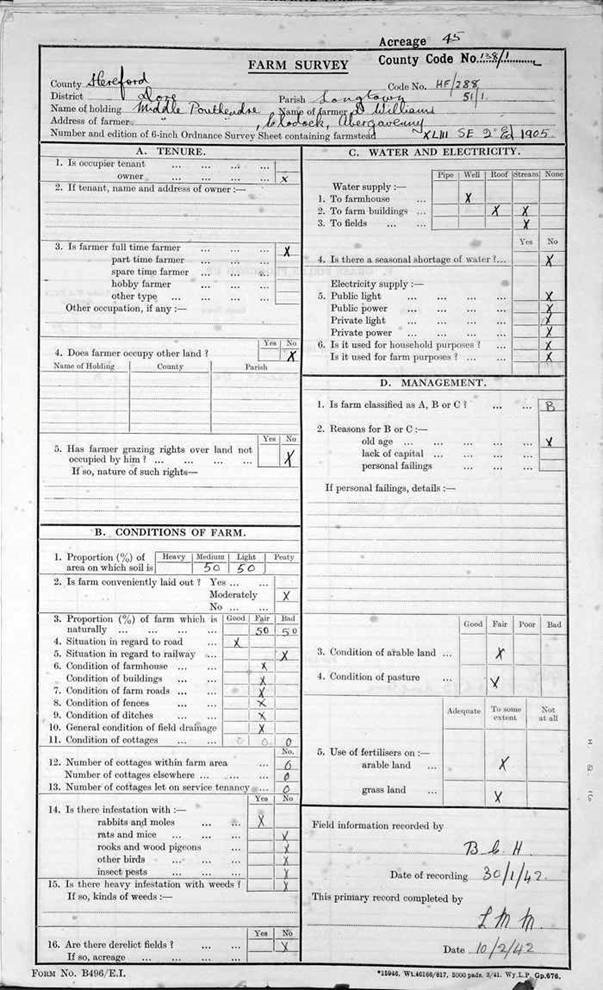
Each part of the survey for a given farm bears that farm’s unique code. This comprises an abbreviation of the county name, the district, the parish number, and the individual farm number: in the example below HF/288 for the Herefordshire district of Dore and 51/1 for the parish of Longtown (51) and the individual farm number 1 for Middle Ponthendre Farm. The grid square reference from the Ordnance Survey is also given for each farm; XLIII SE from the 1905 Second Edition in the case of Middle Ponthendre.
The resulting National Farm Survey consists of two distinct components:
Part 1 - Primary Farm Survey
A full set of photographs of the Primary Farm Survey , designated here as Part 1, can be downloaded as a PDF document containing zoomable images from the link provided. This part of the survey was completed by an inspector who visited the farm and interviewed the farmer. The Primary Farm Survey has six sections:
section A: ‘tenure’, stating whether the farmer was a tenant or owner, full or part time
section B: ‘conditions of farm’, assessing farm layout, soil type, condition of buildings and roads, and the degree of infestation with weeds or pests
section C: water and electricity provision
section D: ‘management’, in which the inspector had to classify the farm reflecting how a farmer managed his resources; well (A), fairly well (B), or badly (C). If B or C were due not to old age or lack of capital but to ‘personal failings’, the inspector had to say what these were. This was to assess where farm management could be improved, but was naturally a controversial part of the survey.
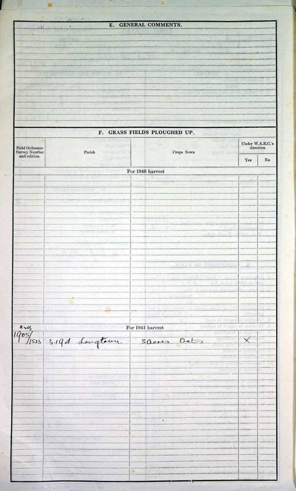
Section E: General Comments
Section F: Grass fields ploughed up for 1940 and 1941 harvest
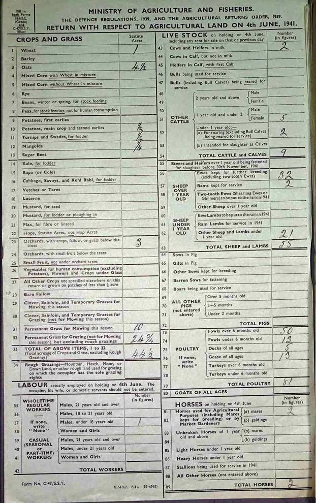
Part 2 - The 4th June 1941 Agricultural Returns
A full set of photographs of the 4th June 1941 Agricultural Returns , here designated as Part 2 of the National Farm Survey, can also be downloaded as a PDF document containing zoomable images from the link provided. These were effectively an enlarged 1941 farm census return. There were up to three forms posted to the farmer for him to complete on 4 June 1941, depending on the nature and scope of the farm's activities; in the case of Longtown farms only one form was used showing details of the crops, livestock, labour and horses on the land.
These records can provide information on farm land, farmers and farm owners, life on a farm, the nature and scope of local agriculture and an indication of the wider community within the parish where a farm was located. As a source for local and family historians the records of the National Farm Survey are of great value, and for the historical geographer these records present an enormous database of land ownership and land usage in mid-20th century Britain.
We are grateful to David Lovelace for permission to publish the collection of photographs he has taken of the original Farm Survey documents for the parish of Longtown, which provides a unique on-line resource giving a snapshot of the local farming community at that point in time.
An index of the farms included in the Longtown Survey archive is as follows:
| Ref | Name | Ref | Name | Ref | Name | Ref | Name |
| 1 | Middle Ponthendre | 28 | Llanwonog | 57 | New Inn Farm | 89 | Glan Olchon |
| 3 | Lower Cwmcoched | 29 | Llandee Farm | 58 | Kellyn Farm | 90 | Little Cwmcoched |
| 4 | Grove Farm | 30 | Old Sun | 59 | Old Court | 100 | Denmark House |
| 5 | Tan House | 31 | Pontrilas | 60 | Yew Tree Farm | 101 | Lower Trewyn |
| 6 | Greyhound | 33 | The Ferns | 62 | Whitehouse |
|
|
| 7 | New Buildings | 34 | Coldbrook | 63 | New House |
|
|
| 8 | Tybach | 35 | Great Cwmcoched | 64 | Castle Bach |
|
|
| 9 | New Inn | 36 | Cwm Farm | 65 | Park Road |
|
|
| 10 | Penydre | 37 | Pen-y-lan | 67 | Mynydd Fyrddin |
|
|
| 11 | Upper Bryn | 39 | Ty Mawr Farm | 68 | Quarry House |
|
|
| 12 | Court Lacca | 41 | Lower House | 69 | Cwmbologue |
|
|
| 13 | Tregoed | 42 | Garn galed | 70 | Upper Wernddu |
|
|
| 14 | Moody Farm | 44 | Lower Hunthouse | 71 | Lower Wernddu |
|
|
| 15 | Lower Trewern | 45 | Clodock Mill | 72 | Great Bilboa |
|
|
| 16 | Trewern | 46 | Welsh Hunthouse | 73 | New Inn [Dulas] |
|
|
| 17 | Trelandon | 47 | Little Hunthouse | 74 | Lower House Farm |
|
|
| 19 | Lower Bryn | 48 | Middle Hunthouse | 75 | Lower Brooks |
|
|
| 20 | New House | 49 | Great Hunthouse | 76 | Garn Farm |
|
|
| 21 | Upper Bryn | 50 | Tycarnot Farm | 77 | Pontys Mill |
|
|
| 22 | Pontynys | 51 | Pen-yr-heol | 79 | Post Office land |
|
|
| 23 | Wayne Farm | 52 | Griedol | 80 | Charity Land |
|
|
| 24 | Pontys Mill | 53 | Ruthland | 81 | Penydre Cottage |
|
|
| 25 | Sunnybank Farm | 54 | Belpha Farm | 82 | Pen Bailey |
|
|
| 26 | Chapel House | 55 | Maerdy | 84 | Upper Brooks |
|
|
| 27 | Upper Ponthendre | 56 | Cwmdulas | 86 | Oaklea |
|
|
Observations:
No explanation is available for the gaps in the farm numbering sequence in the National Archive records.
Note that because of the way the records are presented in the original archive each series of photographs in the PDF download documents commences with a single page showing the identity of the first farm [the front of the form]; all the following photographs are double pages with the first showing the remaining data [the back of the form] for the farm identified on the previous page and the second beginning the entry for the next farm. Care is needed when using these photographs to be sure that the right data is associated with the right property.
Ref: rs_lon_0290